Çakıralan geodata
Çakıralan (Samsun) is a seat of a third-order administrative division; located in Turkey in Europe/Istanbul (GMT+3) time zone. In our database, there are 1323 cities with bigger population. Compared to other cities in Turkey, 93.4% of cities are located further ↓South; 51% of cities are located further →East and 66.9% of cities have lower elevation than Çakıralan. Note1


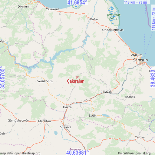
Çakıralan GPS coordinates[2]
41° 10' 5.664" North, 35° 45' 36.612" East
| Map corner | latitude | longitude |
|---|---|---|
| Upper-left | 41.6954°, | 35.05705° |
| Center: | 41.16824°, | 35.76017° |
| Lower-right: | 40.63681°, | 36.4633° |
| Map W x H: | 117.7×117.7 km | = 73.1×73.1mi |
| max Lat: | 42.02683° ⇑6.6% North |
| Çakıralan: | 41.16824° |
| min Lat: | ⇓93.4% South 35.9025° |
| min Long | Çakıralan | max Long |
| 25.90902° | 35.76017° | 44.60099° |
| W 49%⇐ | ⇒51% E |
Elevation
Elevation of Çakıralan is 984 m = 3228 ft, and this is 266.6 m = 875 ft above average elevation for this country.
| Max E: |
2682 m = 8799 ft | 33.1% |
| Çakıralan | 984 m 3228 ft | |
| Avg. | 717.4 m = 2354 ft | |
Min E: |
0 m = 0 ft | 66.9% |
See also: Turkey elevation on elevation.city.
Geographical zone
Çakıralan is located in North temperate zone (between Tropic of Cancer and the Arctic Circle). Distance of this Northern Tropic circle is 1971.6 km =1225.1 mi to South.| Distance of | km | miles | from Çakıralan |
|---|---|---|---|
| North Pole | 5429.6 | 3373.8 | to North |
| Arctic Circle | 2823.7 | 1754.6 | to North |
| Tropic Cancer | 1971.6 | 1225.1 | to South |
| Equator | 4577.5 | 2844.3 | to South |


Nearby cities:
15 places around Çakıralan: (largest is in red/bold)
• Asarcık
42.5 km =26.4 mi,  110°
110°
• Bafra
46.1 km =28.6 mi,  15°
15°
• Beşpınar
45.6 km =28.3 mi,  265°
265°
• Boğazkaya
32.6 km =20.3 mi, 15°
• Havza
23.5 km =14.6 mi,  200°
200°
• Kavak
25.7 km =16 mi, 112°
• Kolay
28 km =17.4 mi,  7°
7°
• Köprübaşı
24.4 km =15.2 mi,  236°
236°
• Ladik
30.7 km =19.1 mi,  158°
158°
• Merzifon
41.2 km =25.6 mi,  217°
217°
• Ondokuzmayıs
45.1 km =28 mi,  34°
34°
• Suluova
38.6 km =24 mi,  194°
194°
• Taflan
40.8 km =25.4 mi,  48°
48°
• Vezirköprü
25.7 km =16 mi,  263°
263°
• Şeyhli
37.4 km =23.2 mi,  137°
137°
Sources, notices
• [Note1] Compared only with cities in Turkey existing in our database
• [Src1] Map data: © OpenStreetMap contributors (CC-BY-SA)
• [Src2] Other city data from geonames.org with taken over terms of usage.
• [Src3] Geographical zone / Annual Mean Temperature by Robert A. Rohde @ Wikipedia
