Enez geodata
Enez (Edirne) is a seat of a second-order administrative division; located in Turkey in Europe/Istanbul (GMT+3) time zone. With population of 4,119 people, there are 770 cities with bigger population in this country. Compared to other cities in Turkey, 81.7% of cities are located further ↓South; 99.9% of cities are located further →East and 95% of cities have higher elevation than Enez. Note1


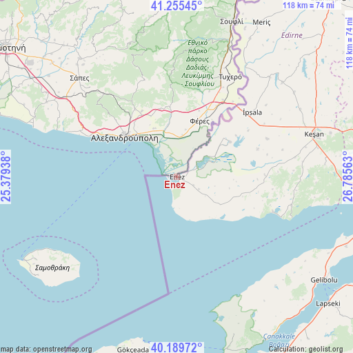
Enez GPS coordinates[2]
40° 43' 28.992" North, 26° 4' 57" East
| Map corner | latitude | longitude |
|---|---|---|
| Upper-left | 41.25545°, | 25.37938° |
| Center: | 40.72472°, | 26.0825° |
| Lower-right: | 40.18972°, | 26.78563° |
| Map W x H: | 118.5×118.5 km | = 73.6×73.6mi |
| max Lat: | 42.02683° ⇑18.3% North |
| Enez: | 40.72472° |
| min Lat: | ⇓81.7% South 35.9025° |
| min Long | Enez | max Long |
| 25.90902° | 26.0825° | 44.60099° |
| W 0.1%⇐ | ⇒99.9% E |
Elevation
Elevation of Enez is 16 m = 52 ft, and this is 701.4 m = 2301 ft below average elevation for this country.
| Max E: |
2682 m = 8799 ft | 95% |
| Avg. | 717.4 m = 2354 ft | |
| Enez | 16 m = 52 ft | |
Min E: |
0 m = 0 ft | 5% |
See also: Turkey elevation on elevation.city.
Geographical zone
Enez is located in North temperate zone (between Tropic of Cancer and the Arctic Circle). Distance of this Northern Tropic circle is 1922.2 km =1194.4 mi to South.| Distance of | km | miles | from Enez |
|---|---|---|---|
| North Pole | 5478.9 | 3404.4 | to North |
| Arctic Circle | 2873 | 1785.2 | to North |
| Tropic Cancer | 1922.2 | 1194.4 | to South |
| Equator | 4528.2 | 2813.7 | to South |


Nearby cities:
15 places around Enez: (largest is in red/bold)
• Bolayır
61.5 km =38.2 mi,  112°
112°
• Eceabat
64.4 km =40 mi,  158°
158°
• Evreşe
67.8 km =42.1 mi,  95°
95°
• Gelibolu
60.8 km =37.8 mi,  125°
125°
• Gökçeada
60 km =37.3 mi,  194°
194°
• Hamidiye
68.1 km =42.3 mi,  45°
45°
• Keşan
48.4 km =30.1 mi,  72°
72°
• Küplü
48.2 km =30 mi,  28°
28°
• Lapseki
66.2 km =41.1 mi, 129°
• Mecidiye
39.7 km =24.7 mi, 103°
• Meriç
59.2 km =36.8 mi, 28°
• Umurbey
70.3 km =43.7 mi,  140°
140°
• Çanakkale
69.2 km =43 mi, 156°
• İbriktepe
47.6 km =29.6 mi, 48°
• İpsala
33.4 km =20.8 mi, 49°
Sources, notices
• [Note1] Compared only with cities in Turkey existing in our database
• [Src1] Map data: © OpenStreetMap contributors (CC-BY-SA)
• [Src2] Other city data from geonames.org with taken over terms of usage.
• [Src3] Geographical zone / Annual Mean Temperature by Robert A. Rohde @ Wikipedia
