Kırık geodata
Kırık (Erzurum) is a seat of a third-order administrative division; located in Turkey in Europe/Istanbul (GMT+3) time zone. In our database, there are 1323 cities with bigger population. Compared to other cities in Turkey, 74.9% of cities are located further ↓South; 80.6% of cities are located further ←West and 99.4% of cities have lower elevation than Kırık. Note1


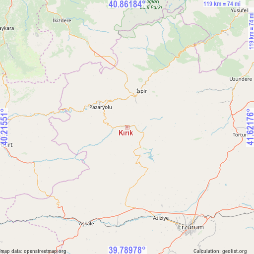
Kırık GPS coordinates[2]
40° 19' 40.584" North, 40° 55' 7.068" East
| Map corner | latitude | longitude |
|---|---|---|
| Upper-left | 40.86184°, | 40.21551° |
| Center: | 40.32794°, | 40.91863° |
| Lower-right: | 39.78978°, | 41.62176° |
| Map W x H: | 119.2×119.2 km | = 74.1×74.1mi |
| max Lat: | 42.02683° ⇑25.1% North |
| Kırık: | 40.32794° |
| min Lat: | ⇓74.9% South 35.9025° |
| min Long | Kırık | max Long |
| 25.90902° | 40.91863° | 44.60099° |
| W 80.6%⇐ | ⇒19.4% E |
Elevation
Elevation of Kırık is 2070 m = 6791 ft, and this is 1352.6 m = 4438 ft above average elevation for this country.
| Max E: |
2682 m = 8799 ft | 0.59999999999999% |
| Kırık | 2070 m 6791 ft | |
| Avg. | 717.4 m = 2354 ft | |
Min E: |
0 m = 0 ft | 99.4% |
See also: Turkey elevation on elevation.city.
Geographical zone
Kırık is located in North temperate zone (between Tropic of Cancer and the Arctic Circle). Distance of this Northern Tropic circle is 1878.1 km =1167 mi to South.| Distance of | km | miles | from Kırık |
|---|---|---|---|
| North Pole | 5523 | 3431.8 | to North |
| Arctic Circle | 2917.1 | 1812.6 | to North |
| Tropic Cancer | 1878.1 | 1167 | to South |
| Equator | 4484 | 2786.2 | to South |


Nearby cities:
15 places around Kırık: (largest is in red/bold)
• Aşkale
49.1 km =30.5 mi,  202°
202°
• Dadaşköy
51.3 km =31.9 mi,  146°
146°
• Dumlu
47.8 km =29.7 mi,  128°
128°
• Erzurum
55.7 km =34.6 mi, 146°
• Ilıca
45 km =28 mi,  160°
160°
• Kandilli
47.4 km =29.5 mi,  188°
188°
• Kazımkarabekir
55.2 km =34.3 mi, 146°
• Maden
46.6 km =29 mi,  249°
249°
• Ovacık
15.7 km =9.8 mi, 154°
• Pazaryolu
15.8 km =9.8 mi,  305°
305°
• Tortum
52.9 km =32.9 mi,  94°
94°
• Yakutiye
56.3 km =35 mi, 148°
• Çamlıkaya
39.8 km =24.7 mi,  29°
29°
• İspir
18 km =11.2 mi,  20°
20°
• Şenyurt
44.5 km =27.7 mi,  75°
75°
Sources, notices
• [Note1] Compared only with cities in Turkey existing in our database
• [Src1] Map data: © OpenStreetMap contributors (CC-BY-SA)
• [Src2] Other city data from geonames.org with taken over terms of usage.
• [Src3] Geographical zone / Annual Mean Temperature by Robert A. Rohde @ Wikipedia
