Urambo geodata
Urambo (Tabora) is a populated place; located in Tanzania in Africa/Dar_es_Salaam (GMT+3) time zone. With population of 23,724 people, there are 95 cities with bigger population in this country. Compared to other cities in Tanzania, 53.1% of cities are located further ↓South; 86.7% of cities are located further →East and 52.4% of cities have higher elevation than Urambo. Note1


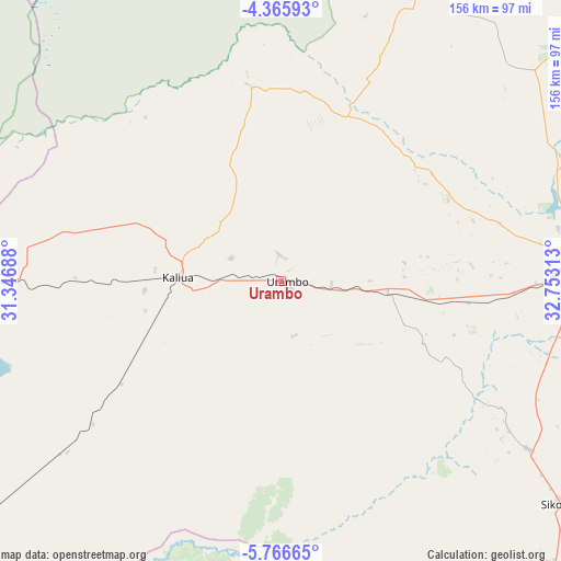
Urambo GPS coordinates[2]
5° 4' 0.012" South, 32° 3' 0" East
| Map corner | latitude | longitude |
|---|---|---|
| Upper-left | -4.36593°, | 31.34688° |
| Center: | -5.06667°, | 32.05° |
| Lower-right: | -5.76665°, | 32.75313° |
| Map W x H: | 155.7×155.7 km | = 96.7×96.7mi |
| max Lat: | -1.14389° ⇑46.9% North |
| Urambo: | -5.06667° |
| min Lat: | ⇓53.1% South -11.36667° |
| min Long | Urambo | max Long |
| 29.62667° | 32.05° | 40.33333° |
| W 13.3%⇐ | ⇒86.7% E |
Elevation
Elevation of Urambo is 1104 m = 3622 ft, and this is 161.2 m = 529 ft above average elevation for this country.
| Max E: |
2377 m = 7799 ft | 52.4% |
| Urambo | 1104 m 3622 ft | |
| Avg. | 942.8 m = 3093 ft | |
Min E: |
0 m = 0 ft | 47.6% |
See also: Tanzania elevation on elevation.city.
Geographical zone
Urambo is located in South Torrid zone (between Equator and Tropic of Capricorn). Distance of Equator is 563.4 km =350.1 mi to North.| Distance of | km | miles | from Urambo |
|---|---|---|---|
| Equator | 563.4 | 350.1 | to North |
| Tropic Capricorn | 2042.6 | 1269.2 | to South |
| Antarctic Circle | 6837.8 | 4248.8 | to South |
| South Pole | 9443.7 | 5868 | to South |


Nearby cities:
15 places around Urambo: (largest is in red/bold)
• Bukene
130.8 km =81.3 mi,  44°
44°
• Isaka
162.5 km =101 mi, 37°
• Kahama
150.1 km =93.3 mi,  23°
23°
• Kaliua
28.4 km =17.6 mi,  271°
271°
• Mabama
54 km =33.6 mi,  97°
97°
• Masumbwe
160.1 km =99.5 mi,  5°
5°
• Mpanda
178.7 km =111 mi,  217°
217°
• Nguruka
111.7 km =69.4 mi, 267°
• Nzega
157.2 km =97.7 mi,  53°
53°
• Sikonge
101.3 km =62.9 mi,  128°
128°
• Tabora
86.2 km =53.6 mi,  86°
86°
• Tinde
183.2 km =113.8 mi, 44°
• Tumbi
75.7 km =47 mi, 90°
• Ushirombo
175.4 km =109 mi,  356°
356°
• Usoke
35 km =21.7 mi,  108°
108°
Sources, notices
• [Note1] Compared only with cities in Tanzania existing in our database
• [Src1] Map data: © OpenStreetMap contributors (CC-BY-SA)
• [Src2] Other city data from geonames.org with taken over terms of usage.
• [Src3] Geographical zone / Annual Mean Temperature by Robert A. Rohde @ Wikipedia
