Tinde geodata
Tinde (Shinyanga) is a populated place; located in Tanzania in Africa/Dar_es_Salaam (GMT+3) time zone. With population of 22,082 people, there are 110 cities with bigger population in this country. Compared to other cities in Tanzania, 71.7% of cities are located further ↓South; 76.9% of cities are located further →East and 54.9% of cities have lower elevation than Tinde. Note1


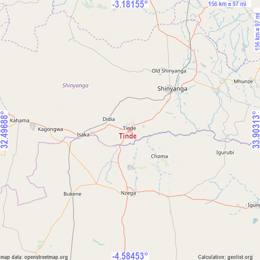
Tinde GPS coordinates[2]
3° 52' 59.988" South, 33° 12' 0" East
| Map corner | latitude | longitude |
|---|---|---|
| Upper-left | -3.18155°, | 32.49688° |
| Center: | -3.88333°, | 33.2° |
| Lower-right: | -4.58453°, | 33.90313° |
| Map W x H: | 156×156 km | = 96.9×96.9mi |
| max Lat: | -1.14389° ⇑28.3% North |
| Tinde: | -3.88333° |
| min Lat: | ⇓71.7% South -11.36667° |
| min Long | Tinde | max Long |
| 29.62667° | 33.2° | 40.33333° |
| W 23.1%⇐ | ⇒76.9% E |
Elevation
Elevation of Tinde is 1154 m = 3786 ft, and this is 211.2 m = 693 ft above average elevation for this country.
| Max E: |
2377 m = 7799 ft | 45.1% |
| Tinde | 1154 m 3786 ft | |
| Avg. | 942.8 m = 3093 ft | |
Min E: |
0 m = 0 ft | 54.9% |
See also: Tanzania elevation on elevation.city.
Geographical zone
Tinde is located in South Torrid zone (between Equator and Tropic of Capricorn). Distance of Equator is 431.8 km =268.3 mi to North.| Distance of | km | miles | from Tinde |
|---|---|---|---|
| Equator | 431.8 | 268.3 | to North |
| Tropic Capricorn | 2174.1 | 1350.9 | to South |
| Antarctic Circle | 6969.4 | 4330.6 | to South |
| South Pole | 9575.3 | 5949.8 | to South |


Nearby cities:
15 places around Tinde: (largest is in red/bold)
• Bukene
52.4 km =32.6 mi,  222°
222°
• Igunga
87.9 km =54.6 mi,  120°
120°
• Igurubi
57 km =35.4 mi,  103°
103°
• Isaka
29.6 km =18.4 mi,  266°
266°
• Kahama
66.8 km =41.5 mi, 274°
• Kishapu
79.7 km =49.5 mi,  68°
68°
• Lalago
96.2 km =59.8 mi,  59°
59°
• Malampaka
91.2 km =56.7 mi,  23°
23°
• Mhango
77.2 km =48 mi,  329°
329°
• Misasi
99.1 km =61.6 mi,  352°
352°
• Mwadui
57.8 km =35.9 mi,  50°
50°
• Nzega
37.1 km =23.1 mi,  182°
182°
• Old Shinyanga
43.2 km =26.8 mi,  30°
30°
• Shinyanga
34.6 km =21.5 mi, 45°
• Songwa
53.8 km =33.4 mi,  40°
40°
Sources, notices
• [Note1] Compared only with cities in Tanzania existing in our database
• [Src1] Map data: © OpenStreetMap contributors (CC-BY-SA)
• [Src2] Other city data from geonames.org with taken over terms of usage.
• [Src3] Geographical zone / Annual Mean Temperature by Robert A. Rohde @ Wikipedia
