Mpanda geodata
Mpanda (Katavi) is a seat of a first-order administrative division; located in Tanzania in Africa/Dar_es_Salaam (GMT+3) time zone. With population of 73,338 people, there are 21 cities with bigger population in this country. Compared to other cities in Tanzania, 59.4% of cities are located further ↑North; 94.4% of cities are located further →East and 52.8% of cities have higher elevation than Mpanda. Note1


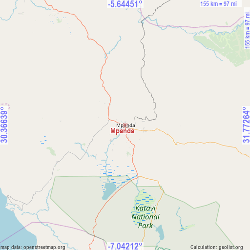
Mpanda GPS coordinates[2]
6° 20' 37.644" South, 31° 4' 10.236" East
| Map corner | latitude | longitude |
|---|---|---|
| Upper-left | -5.64451°, | 30.36639° |
| Center: | -6.34379°, | 31.06951° |
| Lower-right: | -7.04212°, | 31.77264° |
| Map W x H: | 155.4×155.4 km | = 96.6×96.6mi |
| max Lat: | -1.14389° ⇑59.4% North |
| Mpanda: | -6.34379° |
| min Lat: | ⇓40.6% South -11.36667° |
| min Long | Mpanda | max Long |
| 29.62667° | 31.06951° | 40.33333° |
| W 5.6%⇐ | ⇒94.4% E |
Elevation
Elevation of Mpanda is 1100 m = 3609 ft, and this is 157.2 m = 516 ft above average elevation for this country.
| Max E: |
2377 m = 7799 ft | 52.8% |
| Mpanda | 1100 m 3609 ft | |
| Avg. | 942.8 m = 3093 ft | |
Min E: |
0 m = 0 ft | 47.2% |
See also: Mpanda elevation on elevation.city.
Geographical zone
Mpanda is located in South Torrid zone (between Equator and Tropic of Capricorn). Distance of Equator is 705.4 km =438.3 mi to North.| Distance of | km | miles | from Mpanda |
|---|---|---|---|
| Equator | 705.4 | 438.3 | to North |
| Tropic Capricorn | 1900.6 | 1181 | to South |
| Antarctic Circle | 6695.8 | 4160.6 | to South |
| South Pole | 9301.7 | 5779.8 | to South |


Nearby cities:
15 places around Mpanda: (largest is in red/bold)
• Chala
139.5 km =86.7 mi,  171°
171°
• Inyonga
117.7 km =73.1 mi,  110°
110°
• Kaliua
163.6 km =101.7 mi,  29°
29°
• Karema
87.5 km =54.4 mi,  232°
232°
• Kirando
130.1 km =80.8 mi,  203°
203°
• Mabama
210.6 km =130.9 mi,  50°
50°
• Namanyere
130.4 km =81 mi,  180°
180°
• Nguruka
137.3 km =85.3 mi,  358°
358°
• Nkove
180.2 km =112 mi,  187°
187°
• Sikonge
203.6 km =126.5 mi,  67°
67°
• Sumbawanga
190.3 km =118.2 mi,  161°
161°
• Urambo
178.7 km =111 mi,  37°
37°
• Usevia
86 km =53.4 mi, 167°
• Usoke
192.9 km =119.9 mi, 47°
• Uvinza
157 km =97.6 mi,  331°
331°
Sources, notices
• [Note1] Compared only with cities in Tanzania existing in our database
• [Src1] Map data: © OpenStreetMap contributors (CC-BY-SA)
• [Src2] Other city data from geonames.org with taken over terms of usage.
• [Src3] Geographical zone / Annual Mean Temperature by Robert A. Rohde @ Wikipedia
