Kahama geodata
Kahama (Shinyanga) is a populated place; located in Tanzania in Africa/Dar_es_Salaam (GMT+3) time zone. With population of 36,014 people, there are 42 cities with bigger population in this country. Compared to other cities in Tanzania, 72.4% of cities are located further ↓South; 83.9% of cities are located further →East and 67.1% of cities have lower elevation than Kahama. Note1


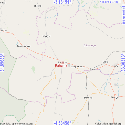
Kahama GPS coordinates[2]
3° 49' 59.988" South, 32° 36' 0" East
| Map corner | latitude | longitude |
|---|---|---|
| Upper-left | -3.13151°, | 31.89688° |
| Center: | -3.83333°, | 32.6° |
| Lower-right: | -4.53458°, | 33.30313° |
| Map W x H: | 156×156 km | = 96.9×96.9mi |
| max Lat: | -1.14389° ⇑27.6% North |
| Kahama: | -3.83333° |
| min Lat: | ⇓72.4% South -11.36667° |
| min Long | Kahama | max Long |
| 29.62667° | 32.6° | 40.33333° |
| W 16.1%⇐ | ⇒83.9% E |
Elevation
Elevation of Kahama is 1249 m = 4098 ft, and this is 306.2 m = 1005 ft above average elevation for this country.
| Max E: |
2377 m = 7799 ft | 32.9% |
| Kahama | 1249 m 4098 ft | |
| Avg. | 942.8 m = 3093 ft | |
Min E: |
0 m = 0 ft | 67.1% |
See also: Tanzania elevation on elevation.city.
Geographical zone
Kahama is located in South Torrid zone (between Equator and Tropic of Capricorn). Distance of Equator is 426.2 km =264.8 mi to North.| Distance of | km | miles | from Kahama |
|---|---|---|---|
| Equator | 426.2 | 264.8 | to North |
| Tropic Capricorn | 2179.7 | 1354.4 | to South |
| Antarctic Circle | 6974.9 | 4334 | to South |
| South Pole | 9580.8 | 5953.2 | to South |


Nearby cities:
15 places around Kahama: (largest is in red/bold)
• Bukene
54.5 km =33.9 mi,  144°
144°
• Geita
114.4 km =71.1 mi,  339°
339°
• Isaka
37.7 km =23.4 mi,  101°
101°
• Kasamwa
110.9 km =68.9 mi,  350°
350°
• Katoro
119.5 km =74.3 mi,  319°
319°
• Masumbwe
51.3 km =31.9 mi,  295°
295°
• Mhango
67.2 km =41.8 mi,  24°
24°
• Misasi
107.1 km =66.5 mi,  30°
30°
• Mwadui
115.3 km =71.6 mi,  74°
74°
• Nzega
77.5 km =48.2 mi,  123°
123°
• Old Shinyanga
94.2 km =58.5 mi, 70°
• Shinyanga
93 km =57.8 mi,  78°
78°
• Songwa
107.6 km =66.9 mi, 70°
• Tinde
66.8 km =41.5 mi,  94°
94°
• Ushirombo
80.1 km =49.8 mi, 298°
Sources, notices
• [Note1] Compared only with cities in Tanzania existing in our database
• [Src1] Map data: © OpenStreetMap contributors (CC-BY-SA)
• [Src2] Other city data from geonames.org with taken over terms of usage.
• [Src3] Geographical zone / Annual Mean Temperature by Robert A. Rohde @ Wikipedia
