Tabora geodata
Tabora is a seat of a first-order administrative division; located in Tanzania in Africa/Dar_es_Salaam (GMT+3) time zone. With population of 145,292 people, there are 10 cities with bigger population in this country. Compared to other cities in Tanzania, 54.9% of cities are located further ↓South; 82.5% of cities are located further →East and 60.8% of cities have lower elevation than Tabora. Note1


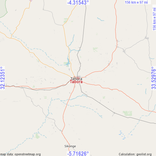
Tabora GPS coordinates[2]
5° 0' 58.392" South, 32° 49' 35.868" East
| Map corner | latitude | longitude |
|---|---|---|
| Upper-left | -4.31543°, | 32.12351° |
| Center: | -5.01622°, | 32.82663° |
| Lower-right: | -5.71626°, | 33.52976° |
| Map W x H: | 155.8×155.8 km | = 96.8×96.8mi |
| max Lat: | -1.14389° ⇑45.1% North |
| Tabora: | -5.01622° |
| min Lat: | ⇓54.9% South -11.36667° |
| min Long | Tabora | max Long |
| 29.62667° | 32.82663° | 40.33333° |
| W 17.5%⇐ | ⇒82.5% E |
Elevation
Elevation of Tabora is 1191 m = 3907 ft, and this is 248.2 m = 814 ft above average elevation for this country.
| Max E: |
2377 m = 7799 ft | 39.2% |
| Tabora | 1191 m 3907 ft | |
| Avg. | 942.8 m = 3093 ft | |
Min E: |
0 m = 0 ft | 60.8% |
See also: Tabora elevation on elevation.city.
Geographical zone
Tabora is located in South Torrid zone (between Equator and Tropic of Capricorn). Distance of Equator is 557.8 km =346.6 mi to North.| Distance of | km | miles | from Tabora |
|---|---|---|---|
| Equator | 557.8 | 346.6 | to North |
| Tropic Capricorn | 2048.2 | 1272.7 | to South |
| Antarctic Circle | 6843.4 | 4252.3 | to South |
| South Pole | 9449.3 | 5871.5 | to South |


Nearby cities:
15 places around Tabora: (largest is in red/bold)
• Bukene
87.3 km =54.2 mi,  4°
4°
• Igunga
142.7 km =88.7 mi,  55°
55°
• Igurubi
148.8 km =92.5 mi,  40°
40°
• Isaka
124.7 km =77.5 mi,  5°
5°
• Kahama
133.9 km =83.2 mi,  349°
349°
• Kaliua
114.5 km =71.1 mi,  267°
267°
• Mabama
35 km =21.7 mi,  248°
248°
• Nzega
97.3 km =60.5 mi,  23°
23°
• Shelui
168.5 km =104.7 mi, 64°
• Shinyanga
164.2 km =102 mi, 23°
• Sikonge
68.9 km =42.8 mi,  185°
185°
• Tinde
132.6 km =82.4 mi, 18°
• Tumbi
11.8 km =7.3 mi,  241°
241°
• Urambo
86.2 km =53.6 mi, 266°
• Usoke
55.4 km =34.4 mi, 252°
Sources, notices
• [Note1] Compared only with cities in Tanzania existing in our database
• [Src1] Map data: © OpenStreetMap contributors (CC-BY-SA)
• [Src2] Other city data from geonames.org with taken over terms of usage.
• [Src3] Geographical zone / Annual Mean Temperature by Robert A. Rohde @ Wikipedia
