Igunga geodata
Igunga (Tabora) is a populated place; located in Tanzania in Africa/Dar_es_Salaam (GMT+3) time zone. With population of 35,644 people, there are 44 cities with bigger population in this country. Compared to other cities in Tanzania, 65.7% of cities are located further ↓South; 67.5% of cities are located further →East and 53.5% of cities have higher elevation than Igunga. Note1


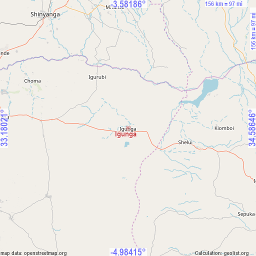
Igunga GPS coordinates[2]
4° 16' 59.988" South, 33° 52' 59.988" East
| Map corner | latitude | longitude |
|---|---|---|
| Upper-left | -3.58186°, | 33.18021° |
| Center: | -4.28333°, | 33.88333° |
| Lower-right: | -4.98415°, | 34.58646° |
| Map W x H: | 155.9×155.9 km | = 96.9×96.9mi |
| max Lat: | -1.14389° ⇑34.3% North |
| Igunga: | -4.28333° |
| min Lat: | ⇓65.7% South -11.36667° |
| min Long | Igunga | max Long |
| 29.62667° | 33.88333° | 40.33333° |
| W 32.5%⇐ | ⇒67.5% E |
Elevation
Elevation of Igunga is 1090 m = 3576 ft, and this is 147.2 m = 483 ft above average elevation for this country.
| Max E: |
2377 m = 7799 ft | 53.5% |
| Igunga | 1090 m 3576 ft | |
| Avg. | 942.8 m = 3093 ft | |
Min E: |
0 m = 0 ft | 46.5% |
See also: Tanzania elevation on elevation.city.
Geographical zone
Igunga is located in South Torrid zone (between Equator and Tropic of Capricorn). Distance of Equator is 476.3 km =296 mi to North.| Distance of | km | miles | from Igunga |
|---|---|---|---|
| Equator | 476.3 | 296 | to North |
| Tropic Capricorn | 2129.7 | 1323.3 | to South |
| Antarctic Circle | 6924.9 | 4302.9 | to South |
| South Pole | 9530.8 | 5922.2 | to South |


Nearby cities:
15 places around Igunga: (largest is in red/bold)
• Igugunu
88.9 km =55.2 mi,  110°
110°
• Igurubi
37.5 km =23.3 mi,  327°
327°
• Kiomboi
53.6 km =33.3 mi,  88°
88°
• Kishapu
74.1 km =46 mi,  358°
358°
• Lalago
93 km =57.8 mi,  4°
4°
• Mwadui
87.4 km =54.3 mi,  338°
338°
• Ndago
62.6 km =38.9 mi,  124°
124°
• Nzega
78 km =48.5 mi,  275°
275°
• Old Shinyanga
97.6 km =60.6 mi, 326°
• Sepuka
88.8 km =55.2 mi,  125°
125°
• Shelui
36.3 km =22.6 mi,  104°
104°
• Shinyanga
85.9 km =53.4 mi,  323°
323°
• Somanda
102.2 km =63.5 mi, 4°
• Songwa
94.5 km =58.7 mi, 334°
• Tinde
87.9 km =54.6 mi,  300°
300°
Sources, notices
• [Note1] Compared only with cities in Tanzania existing in our database
• [Src1] Map data: © OpenStreetMap contributors (CC-BY-SA)
• [Src2] Other city data from geonames.org with taken over terms of usage.
• [Src3] Geographical zone / Annual Mean Temperature by Robert A. Rohde @ Wikipedia
