Geita geodata
Geita is a seat of a first-order administrative division; located in Tanzania in Africa/Dar_es_Salaam (GMT+3) time zone. With population of 40,000 people, there are 34 cities with bigger population in this country. Compared to other cities in Tanzania, 85.3% of cities are located further ↓South; 85.3% of cities are located further →East and 79.7% of cities have lower elevation than Geita. Note1


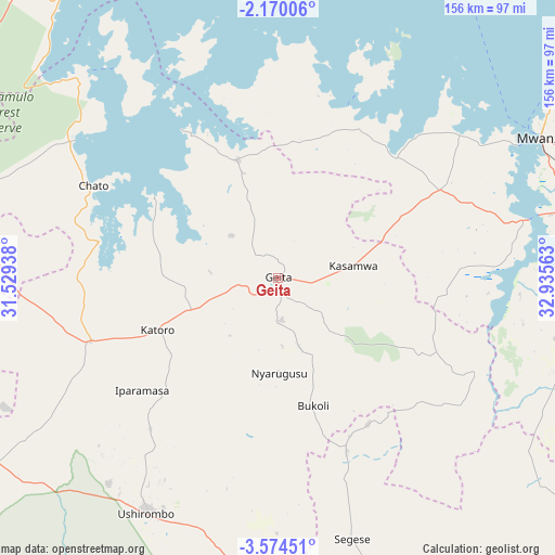
Geita GPS coordinates[2]
2° 52' 21" South, 32° 13' 57" East
| Map corner | latitude | longitude |
|---|---|---|
| Upper-left | -2.17006°, | 31.52938° |
| Center: | -2.8725°, | 32.2325° |
| Lower-right: | -3.57451°, | 32.93563° |
| Map W x H: | 156.2×156.2 km | = 97.1×97.1mi |
| max Lat: | -1.14389° ⇑14.7% North |
| Geita: | -2.8725° |
| min Lat: | ⇓85.3% South -11.36667° |
| min Long | Geita | max Long |
| 29.62667° | 32.2325° | 40.33333° |
| W 14.7%⇐ | ⇒85.3% E |
Elevation
Elevation of Geita is 1416 m = 4646 ft, and this is 473.2 m = 1552 ft above average elevation for this country.
| Max E: |
2377 m = 7799 ft | 20.3% |
| Geita | 1416 m 4646 ft | |
| Avg. | 942.8 m = 3093 ft | |
Min E: |
0 m = 0 ft | 79.7% |
See also: Geita elevation on elevation.city.
Geographical zone
Geita is located in South Torrid zone (between Equator and Tropic of Capricorn). Distance of Equator is 319.4 km =198.5 mi to North.| Distance of | km | miles | from Geita |
|---|---|---|---|
| Equator | 319.4 | 198.5 | to North |
| Tropic Capricorn | 2286.5 | 1420.8 | to South |
| Antarctic Circle | 7081.8 | 4400.4 | to South |
| South Pole | 9687.7 | 6019.7 | to South |


Nearby cities:
15 places around Geita: (largest is in red/bold)
• Biharamulo
106 km =65.9 mi,  284°
284°
• Buseresere
43.1 km =26.8 mi,  247°
247°
• Chato
57.9 km =36 mi,  296°
296°
• Kahama
114.4 km =71.1 mi,  159°
159°
• Kasamwa
22.4 km =13.9 mi,  83°
83°
• Katoro
40.8 km =25.4 mi, 246°
• Masumbwe
84.8 km =52.7 mi,  183°
183°
• Mhango
82.4 km =51.2 mi,  123°
123°
• Misasi
95.5 km =59.3 mi,  98°
98°
• Misungwi
94.5 km =58.7 mi,  88°
88°
• Mwanza
84 km =52.2 mi,  61°
61°
• Nyanguge
113.3 km =70.4 mi,  71°
71°
• Usagara
87.8 km =54.6 mi, 76°
• Ushirombo
75.1 km =46.7 mi,  203°
203°
• Uyovu
90.8 km =56.4 mi,  239°
239°
Sources, notices
• [Note1] Compared only with cities in Tanzania existing in our database
• [Src1] Map data: © OpenStreetMap contributors (CC-BY-SA)
• [Src2] Other city data from geonames.org with taken over terms of usage.
• [Src3] Geographical zone / Annual Mean Temperature by Robert A. Rohde @ Wikipedia
