Namanga geodata
Namanga (Arusha) is a populated place; located in Tanzania in Africa/Dar_es_Salaam (GMT+3) time zone. With population of 12,048 people, there are 212 cities with bigger population in this country. Compared to other cities in Tanzania, 90.2% of cities are located further ↓South; 62.9% of cities are located further ←West and 72.7% of cities have lower elevation than Namanga. Note1


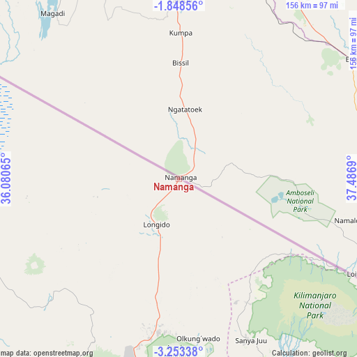
Namanga GPS coordinates[2]
2° 33' 4.176" South, 36° 47' 1.572" East
| Map corner | latitude | longitude |
|---|---|---|
| Upper-left | -1.84856°, | 36.08065° |
| Center: | -2.55116°, | 36.78377° |
| Lower-right: | -3.25338°, | 37.4869° |
| Map W x H: | 156.2×156.2 km | = 97.1×97.1mi |
| max Lat: | -1.14389° ⇑9.8% North |
| Namanga: | -2.55116° |
| min Lat: | ⇓90.2% South -11.36667° |
| min Long | Namanga | max Long |
| 29.62667° | 36.78377° | 40.33333° |
| W 62.9%⇐ | ⇒37.1% E |
Elevation
Elevation of Namanga is 1311 m = 4301 ft, and this is 368.2 m = 1208 ft above average elevation for this country.
| Max E: |
2377 m = 7799 ft | 27.3% |
| Namanga | 1311 m 4301 ft | |
| Avg. | 942.8 m = 3093 ft | |
Min E: |
0 m = 0 ft | 72.7% |
See also: Tanzania elevation on elevation.city.
Geographical zone
Namanga is located in South Torrid zone (between Equator and Tropic of Capricorn). Distance of Equator is 283.7 km =176.3 mi to North.| Distance of | km | miles | from Namanga |
|---|---|---|---|
| Equator | 283.7 | 176.3 | to North |
| Tropic Capricorn | 2322.3 | 1443 | to South |
| Antarctic Circle | 7117.5 | 4422.6 | to South |
| South Pole | 9723.4 | 6041.8 | to South |


Nearby cities:
15 places around Namanga: (largest is in red/bold)
• Arusha
91.4 km =56.8 mi,  187°
187°
• Kingori
84.4 km =52.4 mi,  164°
164°
• Kiratu
151.5 km =94.1 mi,  234°
234°
• Kwakoa
170.3 km =105.8 mi,  142°
142°
• Lembeni
165.3 km =102.7 mi,  145°
145°
• Longido
22.4 km =13.9 mi,  205°
205°
• Mbuguni
114.4 km =71.1 mi,  170°
170°
• Merelani
114.4 km =71.1 mi, 169°
• Monduli
91.1 km =56.6 mi,  203°
203°
• Moshi
107.8 km =67 mi, 145°
• Mto wa Mbu
136.5 km =84.8 mi, 229°
• Ngorongoro
163 km =101.3 mi,  241°
241°
• Nkoaranga
87 km =54.1 mi,  178°
178°
• Poli
87 km =54.1 mi, 178°
• Usa River
91 km =56.5 mi, 175°
Sources, notices
• [Note1] Compared only with cities in Tanzania existing in our database
• [Src1] Map data: © OpenStreetMap contributors (CC-BY-SA)
• [Src2] Other city data from geonames.org with taken over terms of usage.
• [Src3] Geographical zone / Annual Mean Temperature by Robert A. Rohde @ Wikipedia
