Chala geodata
Chala (Rukwa) is a populated place; located in Tanzania in Africa/Dar_es_Salaam (GMT+3) time zone. With population of 22,624 people, there are 107 cities with bigger population in this country. Compared to other cities in Tanzania, 70.6% of cities are located further ↑North; 93% of cities are located further →East and 96.2% of cities have lower elevation than Chala. Note1


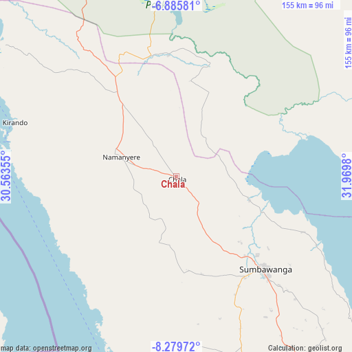
Chala GPS coordinates[2]
7° 34' 59.988" South, 31° 16' 0.012" East
| Map corner | latitude | longitude |
|---|---|---|
| Upper-left | -6.88581°, | 30.56355° |
| Center: | -7.58333°, | 31.26667° |
| Lower-right: | -8.27972°, | 31.9698° |
| Map W x H: | 155×155 km | = 96.3×96.3mi |
| max Lat: | -1.14389° ⇑70.6% North |
| Chala: | -7.58333° |
| min Lat: | ⇓29.4% South -11.36667° |
| min Long | Chala | max Long |
| 29.62667° | 31.26667° | 40.33333° |
| W 7%⇐ | ⇒93% E |
Elevation
Elevation of Chala is 1765 m = 5791 ft, and this is 822.2 m = 2698 ft above average elevation for this country.
| Max E: |
2377 m = 7799 ft | 3.8% |
| Chala | 1765 m 5791 ft | |
| Avg. | 942.8 m = 3093 ft | |
Min E: |
0 m = 0 ft | 96.2% |
See also: Tanzania elevation on elevation.city.
Geographical zone
Chala is located in South Torrid zone (between Equator and Tropic of Capricorn). Distance of Equator is 843.2 km =523.9 mi to North.| Distance of | km | miles | from Chala |
|---|---|---|---|
| Equator | 843.2 | 523.9 | to North |
| Tropic Capricorn | 1762.7 | 1095.3 | to South |
| Antarctic Circle | 6558 | 4075 | to South |
| South Pole | 9163.9 | 5694.2 | to South |


Nearby cities:
15 places around Chala: (largest is in red/bold)
• Inyonga
130.7 km =81.2 mi,  42°
42°
• Karema
124.6 km =77.4 mi,  312°
312°
• Kirando
75.8 km =47.1 mi,  284°
284°
• Laela
139.3 km =86.6 mi,  141°
141°
• Matai
84.3 km =52.4 mi,  160°
160°
• Mlowo
245.9 km =152.8 mi,  129°
129°
• Mpanda
139.5 km =86.7 mi,  351°
351°
• Namanyere
25 km =15.5 mi,  287°
287°
• Nguruka
276.2 km =171.6 mi, 354°
• Nkove
61.4 km =38.2 mi,  228°
228°
• Sikonge
272.9 km =169.6 mi, 37°
• Sumbawanga
57.5 km =35.7 mi, 137°
• Tunduma
252.3 km =156.8 mi, 139°
• Usevia
53.9 km =33.5 mi,  356°
356°
• Vwawa
249.8 km =155.2 mi, 132°
Sources, notices
• [Note1] Compared only with cities in Tanzania existing in our database
• [Src1] Map data: © OpenStreetMap contributors (CC-BY-SA)
• [Src2] Other city data from geonames.org with taken over terms of usage.
• [Src3] Geographical zone / Annual Mean Temperature by Robert A. Rohde @ Wikipedia
