Magugu geodata
Magugu (Manyara) is a populated place; located in Tanzania in Africa/Dar_es_Salaam (GMT+3) time zone. With population of 26,131 people, there are 80 cities with bigger population in this country. Compared to other cities in Tanzania, 70.3% of cities are located further ↓South; 55.9% of cities are located further ←West and 56.6% of cities have higher elevation than Magugu. Note1


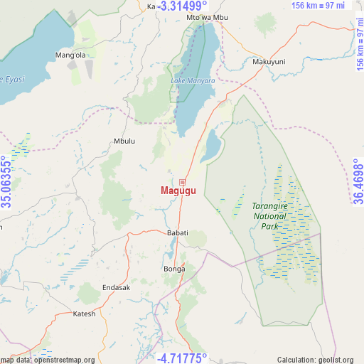
Magugu GPS coordinates[2]
4° 1' 0.012" South, 35° 46' 0.012" East
| Map corner | latitude | longitude |
|---|---|---|
| Upper-left | -3.31499°, | 35.06355° |
| Center: | -4.01667°, | 35.76667° |
| Lower-right: | -4.71775°, | 36.4698° |
| Map W x H: | 156×156 km | = 96.9×96.9mi |
| max Lat: | -1.14389° ⇑29.7% North |
| Magugu: | -4.01667° |
| min Lat: | ⇓70.3% South -11.36667° |
| min Long | Magugu | max Long |
| 29.62667° | 35.76667° | 40.33333° |
| W 55.9%⇐ | ⇒44.1% E |
Elevation
Elevation of Magugu is 1013 m = 3323 ft, and this is 70.2 m = 230 ft above average elevation for this country.
| Max E: |
2377 m = 7799 ft | 56.6% |
| Magugu | 1013 m 3323 ft | |
| Avg. | 942.8 m = 3093 ft | |
Min E: |
0 m = 0 ft | 43.4% |
See also: Tanzania elevation on elevation.city.
Geographical zone
Magugu is located in South Torrid zone (between Equator and Tropic of Capricorn). Distance of Equator is 446.6 km =277.5 mi to North.| Distance of | km | miles | from Magugu |
|---|---|---|---|
| Equator | 446.6 | 277.5 | to North |
| Tropic Capricorn | 2159.3 | 1341.7 | to South |
| Antarctic Circle | 6954.6 | 4321.4 | to South |
| South Pole | 9560.5 | 5940.6 | to South |


Nearby cities:
15 places around Magugu: (largest is in red/bold)
• Babati
22.3 km =13.9 mi,  184°
184°
• Bashanet
45.7 km =28.4 mi,  238°
238°
• Basotu
85.2 km =52.9 mi, 242°
• Dareda
32.7 km =20.3 mi,  227°
227°
• Dongobesh
42.9 km =26.7 mi,  262°
262°
• Endasak
52.4 km =32.6 mi,  211°
211°
• Galappo
29.3 km =18.2 mi,  161°
161°
• Katesh
70.6 km =43.9 mi,  216°
216°
• Kiratu
76.8 km =47.7 mi,  351°
351°
• Kondoa
98.2 km =61 mi, 178°
• Mbulu
31.8 km =19.8 mi,  305°
305°
• Monduli
110 km =68.4 mi,  43°
43°
• Mto wa Mbu
74.7 km =46.4 mi,  7°
7°
• Nangwa
61.1 km =38 mi, 215°
• Ngorongoro
91.8 km =57 mi,  340°
340°
Sources, notices
• [Note1] Compared only with cities in Tanzania existing in our database
• [Src1] Map data: © OpenStreetMap contributors (CC-BY-SA)
• [Src2] Other city data from geonames.org with taken over terms of usage.
• [Src3] Geographical zone / Annual Mean Temperature by Robert A. Rohde @ Wikipedia
