Chato geodata
Chato (Geita) is a populated place; located in Tanzania in Africa/Dar_es_Salaam (GMT+3) time zone. With population of 27,776 people, there are 72 cities with bigger population in this country. Compared to other cities in Tanzania, 88.8% of cities are located further ↓South; 88.8% of cities are located further →East and 53.8% of cities have lower elevation than Chato. Note1


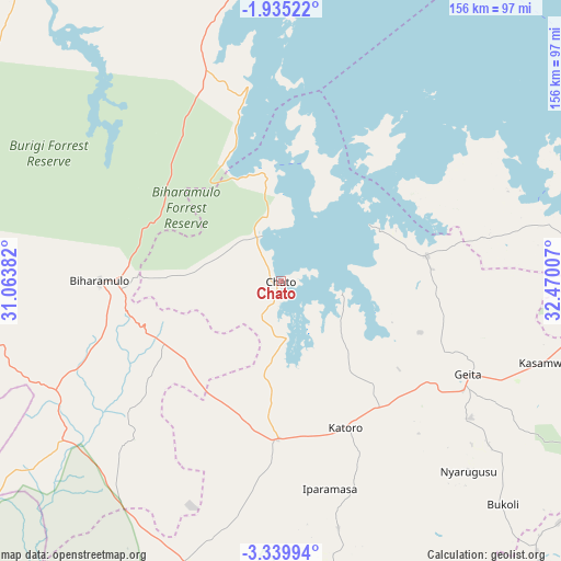
Chato GPS coordinates[2]
2° 38' 16.008" South, 31° 46' 0.984" East
| Map corner | latitude | longitude |
|---|---|---|
| Upper-left | -1.93522°, | 31.06382° |
| Center: | -2.63778°, | 31.76694° |
| Lower-right: | -3.33994°, | 32.47007° |
| Map W x H: | 156.2×156.2 km | = 97.1×97.1mi |
| max Lat: | -1.14389° ⇑11.2% North |
| Chato: | -2.63778° |
| min Lat: | ⇓88.8% South -11.36667° |
| min Long | Chato | max Long |
| 29.62667° | 31.76694° | 40.33333° |
| W 11.2%⇐ | ⇒88.8% E |
Elevation
Elevation of Chato is 1150 m = 3773 ft, and this is 207.2 m = 680 ft above average elevation for this country.
| Max E: |
2377 m = 7799 ft | 46.2% |
| Chato | 1150 m 3773 ft | |
| Avg. | 942.8 m = 3093 ft | |
Min E: |
0 m = 0 ft | 53.8% |
See also: Tanzania elevation on elevation.city.
Geographical zone
Chato is located in South Torrid zone (between Equator and Tropic of Capricorn). Distance of Equator is 293.3 km =182.2 mi to North.| Distance of | km | miles | from Chato |
|---|---|---|---|
| Equator | 293.3 | 182.2 | to North |
| Tropic Capricorn | 2312.6 | 1437 | to South |
| Antarctic Circle | 7107.9 | 4416.6 | to South |
| South Pole | 9713.8 | 6035.9 | to South |


Nearby cities:
15 places around Chato: (largest is in red/bold)
• Biharamulo
50.9 km =31.6 mi,  270°
270°
• Buseresere
44.5 km =27.7 mi,  164°
164°
• Geita
57.9 km =36 mi,  116°
116°
• Kakonko
114.4 km =71.1 mi,  231°
231°
• Kamachumu
114.5 km =71.1 mi,  351°
351°
• Kasamwa
77.7 km =48.3 mi,  107°
107°
• Katoro
44.9 km =27.9 mi, 161°
• Masumbwe
120 km =74.6 mi, 157°
• Muleba
89.6 km =55.7 mi, 351°
• Mwanza
126.6 km =78.7 mi,  83°
83°
• Ngara
124.2 km =77.2 mi,  276°
276°
• Nshamba
96.4 km =59.9 mi, 345°
• Rulenge
126.3 km =78.5 mi, 265°
• Ushirombo
97.5 km =60.6 mi,  167°
167°
• Uyovu
76.6 km =47.6 mi,  200°
200°
Sources, notices
• [Note1] Compared only with cities in Tanzania existing in our database
• [Src1] Map data: © OpenStreetMap contributors (CC-BY-SA)
• [Src2] Other city data from geonames.org with taken over terms of usage.
• [Src3] Geographical zone / Annual Mean Temperature by Robert A. Rohde @ Wikipedia
