Katoro geodata
Katoro (Geita) is a populated place; located in Tanzania in Africa/Dar_es_Salaam (GMT+3) time zone. With population of 49,691 people, there are 29 cities with bigger population in this country. Compared to other cities in Tanzania, 83.9% of cities are located further ↓South; 87.4% of cities are located further →East and 71% of cities have lower elevation than Katoro. Note1


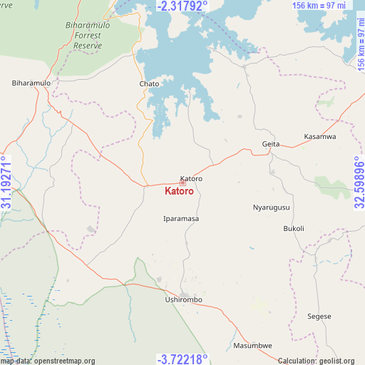
Katoro GPS coordinates[2]
3° 1' 13.008" South, 31° 53' 44.988" East
| Map corner | latitude | longitude |
|---|---|---|
| Upper-left | -2.31792°, | 31.19271° |
| Center: | -3.02028°, | 31.89583° |
| Lower-right: | -3.72218°, | 32.59896° |
| Map W x H: | 156.1×156.1 km | = 97×97mi |
| max Lat: | -1.14389° ⇑16.1% North |
| Katoro: | -3.02028° |
| min Lat: | ⇓83.9% South -11.36667° |
| min Long | Katoro | max Long |
| 29.62667° | 31.89583° | 40.33333° |
| W 12.6%⇐ | ⇒87.4% E |
Elevation
Elevation of Katoro is 1297 m = 4255 ft, and this is 354.2 m = 1162 ft above average elevation for this country.
| Max E: |
2377 m = 7799 ft | 29% |
| Katoro | 1297 m 4255 ft | |
| Avg. | 942.8 m = 3093 ft | |
Min E: |
0 m = 0 ft | 71% |
See also: Katoro elevation on elevation.city.
Geographical zone
Katoro is located in South Torrid zone (between Equator and Tropic of Capricorn). Distance of Equator is 335.8 km =208.7 mi to North.| Distance of | km | miles | from Katoro |
|---|---|---|---|
| Equator | 335.8 | 208.7 | to North |
| Tropic Capricorn | 2270.1 | 1410.6 | to South |
| Antarctic Circle | 7065.4 | 4390.2 | to South |
| South Pole | 9671.2 | 6009.4 | to South |


Nearby cities:
15 places around Katoro: (largest is in red/bold)
• Biharamulo
78.2 km =48.6 mi,  303°
303°
• Buseresere
2.4 km =1.5 mi,  261°
261°
• Chato
44.9 km =27.9 mi,  341°
341°
• Geita
40.8 km =25.4 mi,  66°
66°
• Kahama
119.5 km =74.3 mi,  139°
139°
• Kakonko
107.5 km =66.8 mi,  254°
254°
• Kasamwa
62.6 km =38.9 mi, 72°
• Masumbwe
75.3 km =46.8 mi,  154°
154°
• Mhango
109.9 km =68.3 mi,  105°
105°
• Misasi
131.9 km =82 mi,  89°
89°
• Misungwi
133.2 km =82.8 mi,  81°
81°
• Mwanza
124.8 km =77.5 mi,  63°
63°
• Usagara
128.2 km =79.7 mi, 73°
• Ushirombo
53 km =32.9 mi,  171°
171°
• Uyovu
50.4 km =31.3 mi,  234°
234°
Sources, notices
• [Note1] Compared only with cities in Tanzania existing in our database
• [Src1] Map data: © OpenStreetMap contributors (CC-BY-SA)
• [Src2] Other city data from geonames.org with taken over terms of usage.
• [Src3] Geographical zone / Annual Mean Temperature by Robert A. Rohde @ Wikipedia
