Kiratu geodata
Kiratu (Arusha) is a populated place; located in Tanzania in Africa/Dar_es_Salaam (GMT+3) time zone. With population of 19,803 people, there are 126 cities with bigger population in this country. Compared to other cities in Tanzania, 79.4% of cities are located further ↓South; 54.2% of cities are located further ←West and 86.4% of cities have lower elevation than Kiratu. Note1


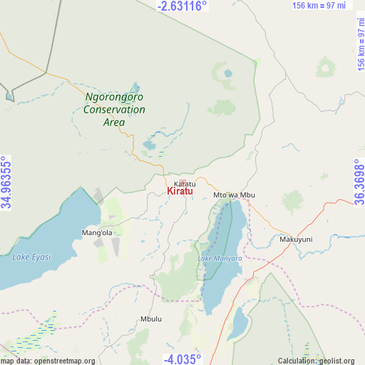
Kiratu GPS coordinates[2]
3° 19' 59.988" South, 35° 40' 0.012" East
| Map corner | latitude | longitude |
|---|---|---|
| Upper-left | -2.63116°, | 34.96355° |
| Center: | -3.33333°, | 35.66667° |
| Lower-right: | -4.035°, | 36.3698° |
| Map W x H: | 156.1×156.1 km | = 97×97mi |
| max Lat: | -1.14389° ⇑20.6% North |
| Kiratu: | -3.33333° |
| min Lat: | ⇓79.4% South -11.36667° |
| min Long | Kiratu | max Long |
| 29.62667° | 35.66667° | 40.33333° |
| W 54.2%⇐ | ⇒45.8% E |
Elevation
Elevation of Kiratu is 1541 m = 5056 ft, and this is 598.2 m = 1963 ft above average elevation for this country.
| Max E: |
2377 m = 7799 ft | 13.6% |
| Kiratu | 1541 m 5056 ft | |
| Avg. | 942.8 m = 3093 ft | |
Min E: |
0 m = 0 ft | 86.4% |
See also: Tanzania elevation on elevation.city.
Geographical zone
Kiratu is located in South Torrid zone (between Equator and Tropic of Capricorn). Distance of Equator is 370.6 km =230.3 mi to North.| Distance of | km | miles | from Kiratu |
|---|---|---|---|
| Equator | 370.6 | 230.3 | to North |
| Tropic Capricorn | 2235.3 | 1389 | to South |
| Antarctic Circle | 7030.5 | 4368.5 | to South |
| South Pole | 9636.4 | 5987.8 | to South |


Nearby cities:
15 places around Kiratu: (largest is in red/bold)
• Arusha
112.9 km =70.2 mi,  91°
91°
• Babati
98.7 km =61.3 mi,  174°
174°
• Bashanet
103.8 km =64.5 mi,  195°
195°
• Dareda
99.1 km =61.6 mi,  187°
187°
• Dongobesh
87.4 km =54.3 mi, 201°
• Endasak
121.6 km =75.6 mi, 187°
• Galappo
105.8 km =65.7 mi, 168°
• Magugu
76.8 km =47.7 mi, 171°
• Mbulu
59.3 km =36.8 mi, 194°
• Monduli
87 km =54.1 mi, 87°
• Mto wa Mbu
20.4 km =12.7 mi,  95°
95°
• Nangwa
128.3 km =79.7 mi, 190°
• Ngorongoro
22.5 km =14 mi,  297°
297°
• Nkoaranga
125.8 km =78.2 mi, 90°
• Poli
125.8 km =78.2 mi, 90°
Sources, notices
• [Note1] Compared only with cities in Tanzania existing in our database
• [Src1] Map data: © OpenStreetMap contributors (CC-BY-SA)
• [Src2] Other city data from geonames.org with taken over terms of usage.
• [Src3] Geographical zone / Annual Mean Temperature by Robert A. Rohde @ Wikipedia
