Ilula geodata
Ilula (Iringa) is a populated place; located in Tanzania in Africa/Dar_es_Salaam (GMT+3) time zone. With population of 29,193 people, there are 66 cities with bigger population in this country. Compared to other cities in Tanzania, 71.7% of cities are located further ↑North; 58.4% of cities are located further ←West and 76.6% of cities have lower elevation than Ilula. Note1


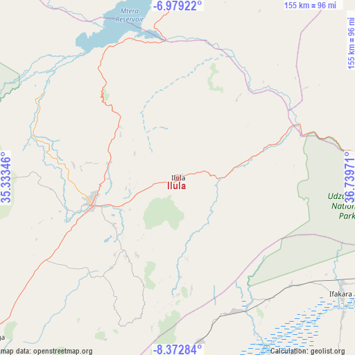
Ilula GPS coordinates[2]
7° 40' 35.76" South, 36° 2' 11.688" East
| Map corner | latitude | longitude |
|---|---|---|
| Upper-left | -6.97922°, | 35.33346° |
| Center: | -7.6766°, | 36.03658° |
| Lower-right: | -8.37284°, | 36.73971° |
| Map W x H: | 155×155 km | = 96.3×96.3mi |
| max Lat: | -1.14389° ⇑71.7% North |
| Ilula: | -7.6766° |
| min Lat: | ⇓28.3% South -11.36667° |
| min Long | Ilula | max Long |
| 29.62667° | 36.03658° | 40.33333° |
| W 58.4%⇐ | ⇒41.6% E |
Elevation
Elevation of Ilula is 1374 m = 4508 ft, and this is 431.2 m = 1415 ft above average elevation for this country.
| Max E: |
2377 m = 7799 ft | 23.4% |
| Ilula | 1374 m 4508 ft | |
| Avg. | 942.8 m = 3093 ft | |
Min E: |
0 m = 0 ft | 76.6% |
See also: Tanzania elevation on elevation.city.
Geographical zone
Ilula is located in South Torrid zone (between Equator and Tropic of Capricorn). Distance of Equator is 853.6 km =530.4 mi to North.| Distance of | km | miles | from Ilula |
|---|---|---|---|
| Equator | 853.6 | 530.4 | to North |
| Tropic Capricorn | 1752.4 | 1088.9 | to South |
| Antarctic Circle | 6547.6 | 4068.5 | to South |
| South Pole | 9153.5 | 5687.7 | to South |


Nearby cities:
15 places around Ilula: (largest is in red/bold)
• Ifakara
87.5 km =54.4 mi,  125°
125°
• Iringa
38.4 km =23.9 mi,  254°
254°
• Izazi
62.7 km =39 mi,  327°
327°
• Kibakwe
112.8 km =70.1 mi,  18°
18°
• Kidatu
101.5 km =63.1 mi,  91°
91°
• Kidodi
107 km =66.5 mi, 85°
• Kilosa
140.3 km =87.2 mi,  48°
48°
• Lupiro
104.8 km =65.1 mi,  138°
138°
• Mafinga
117 km =72.7 mi,  293°
293°
• Mahenge
134.7 km =83.7 mi,  146°
146°
• Makungu
143.8 km =89.4 mi,  215°
215°
• Malinyi
140.1 km =87.1 mi,  175°
175°
• Mikumi
108.6 km =67.5 mi,  73°
73°
• Mlimba
127.2 km =79 mi,  190°
190°
• Mtimbira
127.8 km =79.4 mi,  164°
164°
Sources, notices
• [Note1] Compared only with cities in Tanzania existing in our database
• [Src1] Map data: © OpenStreetMap contributors (CC-BY-SA)
• [Src2] Other city data from geonames.org with taken over terms of usage.
• [Src3] Geographical zone / Annual Mean Temperature by Robert A. Rohde @ Wikipedia
