Mafinga geodata
Mafinga (Iringa) is a populated place; located in Tanzania in Africa/Dar_es_Salaam (GMT+3) time zone. With population of 34,958 people, there are 47 cities with bigger population in this country. Compared to other cities in Tanzania, 68.9% of cities are located further ↑North; 51% of cities are located further →East and 56.3% of cities have higher elevation than Mafinga. Note1


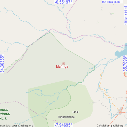
Mafinga GPS coordinates[2]
7° 15' 0" South, 35° 4' 0.012" East
| Map corner | latitude | longitude |
|---|---|---|
| Upper-left | -6.55197°, | 34.36355° |
| Center: | -7.25°, | 35.06667° |
| Lower-right: | -7.94695°, | 35.7698° |
| Map W x H: | 155.1×155.1 km | = 96.4×96.4mi |
| max Lat: | -1.14389° ⇑68.9% North |
| Mafinga: | -7.25° |
| min Lat: | ⇓31.1% South -11.36667° |
| min Long | Mafinga | max Long |
| 29.62667° | 35.06667° | 40.33333° |
| W 49%⇐ | ⇒51% E |
Elevation
Elevation of Mafinga is 1018 m = 3340 ft, and this is 75.2 m = 247 ft above average elevation for this country.
| Max E: |
2377 m = 7799 ft | 56.3% |
| Mafinga | 1018 m 3340 ft | |
| Avg. | 942.8 m = 3093 ft | |
Min E: |
0 m = 0 ft | 43.7% |
See also: Tanzania elevation on elevation.city.
Geographical zone
Mafinga is located in South Torrid zone (between Equator and Tropic of Capricorn). Distance of Equator is 806.1 km =500.9 mi to North.| Distance of | km | miles | from Mafinga |
|---|---|---|---|
| Equator | 806.1 | 500.9 | to North |
| Tropic Capricorn | 1799.8 | 1118.3 | to South |
| Antarctic Circle | 6595 | 4097.9 | to South |
| South Pole | 9200.9 | 5717.2 | to South |


Nearby cities:
15 places around Mafinga: (largest is in red/bold)
• Dodoma
141 km =87.6 mi,  31°
31°
• Dunda
131.8 km =81.9 mi,  223°
223°
• Ilula
117 km =72.7 mi,  113°
113°
• Iringa
90.4 km =56.2 mi,  129°
129°
• Izazi
73.7 km =45.8 mi,  85°
85°
• Kibakwe
155.2 km =96.4 mi,  67°
67°
• Kilimatinde
156.2 km =97.1 mi,  355°
355°
• Kintinku
153.1 km =95.1 mi,  6°
6°
• Kisasa
143.9 km =89.4 mi, 33°
• Makumbako
179.7 km =111.7 mi,  188°
188°
• Makungu
166.6 km =103.5 mi,  171°
171°
• Malangali
148.3 km =92.1 mi, 189°
• Mgandu
177.5 km =110.3 mi,  324°
324°
• Msanga
170.9 km =106.2 mi,  38°
38°
• Rujewa
177.9 km =110.5 mi,  205°
205°
Sources, notices
• [Note1] Compared only with cities in Tanzania existing in our database
• [Src1] Map data: © OpenStreetMap contributors (CC-BY-SA)
• [Src2] Other city data from geonames.org with taken over terms of usage.
• [Src3] Geographical zone / Annual Mean Temperature by Robert A. Rohde @ Wikipedia
