Iringa geodata
Iringa is a seat of a first-order administrative division; located in Tanzania in Africa/Dar_es_Salaam (GMT+3) time zone. With population of 111,820 people, there are 13 cities with bigger population in this country. Compared to other cities in Tanzania, 72.7% of cities are located further ↑North; 54.5% of cities are located further ←West and 91.6% of cities have lower elevation than Iringa. Note1


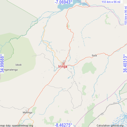
Iringa GPS coordinates[2]
7° 46' 0.012" South, 35° 42' 0" East
| Map corner | latitude | longitude |
|---|---|---|
| Upper-left | -7.06943°, | 34.99688° |
| Center: | -7.76667°, | 35.7° |
| Lower-right: | -8.46275°, | 36.40313° |
| Map W x H: | 154.9×154.9 km | = 96.3×96.3mi |
| max Lat: | -1.14389° ⇑72.7% North |
| Iringa: | -7.76667° |
| min Lat: | ⇓27.3% South -11.36667° |
| min Long | Iringa | max Long |
| 29.62667° | 35.7° | 40.33333° |
| W 54.5%⇐ | ⇒45.5% E |
Elevation
Elevation of Iringa is 1625 m = 5331 ft, and this is 682.2 m = 2238 ft above average elevation for this country.
| Max E: |
2377 m = 7799 ft | 8.4% |
| Iringa | 1625 m 5331 ft | |
| Avg. | 942.8 m = 3093 ft | |
Min E: |
0 m = 0 ft | 91.6% |
See also: Iringa elevation on elevation.city.
Geographical zone
Iringa is located in South Torrid zone (between Equator and Tropic of Capricorn). Distance of Equator is 863.6 km =536.6 mi to North.| Distance of | km | miles | from Iringa |
|---|---|---|---|
| Equator | 863.6 | 536.6 | to North |
| Tropic Capricorn | 1742.3 | 1082.6 | to South |
| Antarctic Circle | 6537.6 | 4062.3 | to South |
| South Pole | 9143.5 | 5681.5 | to South |


Nearby cities:
15 places around Iringa: (largest is in red/bold)
• Ifakara
115.7 km =71.9 mi,  110°
110°
• Ilula
38.4 km =23.9 mi,  74°
74°
• Izazi
63.1 km =39.2 mi,  3°
3°
• Kibakwe
138 km =85.7 mi,  32°
32°
• Kidatu
138.7 km =86.2 mi,  86°
86°
• Kidodi
144.9 km =90 mi,  82°
82°
• Lupiro
126.6 km =78.7 mi,  122°
122°
• Mafinga
90.4 km =56.2 mi,  309°
309°
• Mahenge
151.3 km =94 mi,  132°
132°
• Makungu
116.9 km =72.6 mi,  203°
203°
• Malangali
129.1 km =80.2 mi,  226°
226°
• Malinyi
138.2 km =85.9 mi,  159°
159°
• Mikumi
147.1 km =91.4 mi, 74°
• Mlimba
115.6 km =71.8 mi,  173°
173°
• Mtimbira
133.8 km =83.1 mi,  147°
147°
Sources, notices
• [Note1] Compared only with cities in Tanzania existing in our database
• [Src1] Map data: © OpenStreetMap contributors (CC-BY-SA)
• [Src2] Other city data from geonames.org with taken over terms of usage.
• [Src3] Geographical zone / Annual Mean Temperature by Robert A. Rohde @ Wikipedia
