Yelanets’ geodata
Yelanets’ (Mykolaiv) is a seat of a second-order administrative division; located in Ukraine in Europe/Kiev (GMT+3) time zone. In our database, there are 1661 cities with bigger population. Compared to other cities in Ukraine, 59.2% of cities are located further ↑North; 57.9% of cities are located further →East and 70.6% of cities have higher elevation than Yelanets’. Note1


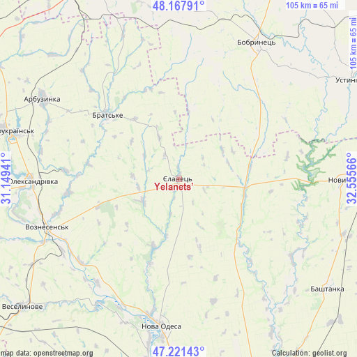
Yelanets’ GPS coordinates[2]
47° 41' 48.552" North, 31° 51' 9.108" East
| Map corner | latitude | longitude |
|---|---|---|
| Upper-left | 48.16791°, | 31.14941° |
| Center: | 47.69682°, | 31.85253° |
| Lower-right: | 47.22143°, | 32.55566° |
| Map W x H: | 105.2×105.2 km | = 65.4×65.4mi |
| max Lat: | 52.18903° ⇑59.2% North |
| Yelanets’: | 47.69682° |
| min Lat: | ⇓40.8% South 44.39214° |
| min Long | Yelanets’ | max Long |
| 22.20555° | 31.85253° | 40.13222° |
| W 42.1%⇐ | ⇒57.9% E |
Elevation
Elevation of Yelanets’ is 73 m = 240 ft, and this is 82.8 m = 272 ft below average elevation for this country.
| Max E: |
886 m = 2907 ft | 70.6% |
| Avg. | 155.8 m = 511 ft | |
| Yelanets’ | 73 m = 240 ft | |
Min E: |
-3 m = -10 ft | 29.4% |
See also: Ukraine elevation on elevation.city.
Geographical zone
Yelanets’ is located in North temperate zone (between Tropic of Cancer and the Arctic Circle). Distance of this North polar circle is 2097.8 km =1303.5 mi to North.| Distance of | km | miles | from Yelanets’ |
|---|---|---|---|
| North Pole | 4703.7 | 2922.7 | to North |
| Arctic Circle | 2097.8 | 1303.5 | to North |
| Tropic Cancer | 2697.5 | 1676.1 | to South |
| Equator | 5303.4 | 3295.4 | to South |


Nearby cities:
15 places around Yelanets’: (largest is in red/bold)
• Arbuzynka
46.3 km =28.8 mi,  300°
300°
• Bashtanka
54.5 km =33.9 mi,  126°
126°
• Bobrynets
46.6 km =29 mi,  30°
30°
• Brats’ke
27.3 km =17 mi,  312°
312°
• Domanivka
65.1 km =40.5 mi,  263°
263°
• Kompaniyivka
67.1 km =41.7 mi,  23°
23°
• Kostyantynivka
55.5 km =34.5 mi,  285°
285°
• Nova Odesa
43.6 km =27.1 mi,  186°
186°
• Novyy Buh
50.1 km =31.1 mi,  90°
90°
• Ol'shanskoye
57.2 km =35.5 mi,  184°
184°
• Rivne
61.7 km =38.3 mi,  353°
353°
• Ustynivka
58.6 km =36.4 mi,  60°
60°
• Veselynove
59.8 km =37.2 mi,  230°
230°
• Voznesensk
41.8 km =26 mi,  249°
249°
• Yuzhnoukrains'k
51.8 km =32.2 mi, 285°
Sources, notices
• [Note1] Compared only with cities in Ukraine existing in our database
• [Src1] Map data: © OpenStreetMap contributors (CC-BY-SA)
• [Src2] Other city data from geonames.org with taken over terms of usage.
• [Src3] Geographical zone / Annual Mean Temperature by Robert A. Rohde @ Wikipedia
