Zhytomyr geodata
Zhytomyr is a seat of a first-order administrative division; located in Ukraine in Europe/Kiev (GMT+3) time zone. With population of 282,192 people, there are 21 cities with bigger population in this country. Compared to other cities in Ukraine, 87.3% of cities are located further ↓South; 74% of cities are located further →East and 75.7% of cities have lower elevation than Zhytomyr. Note1
Administrative division(s):
- Level 1: Zhytomyr
- Level 2: Zhytomyr City Amalgamated Territorial Commmunity


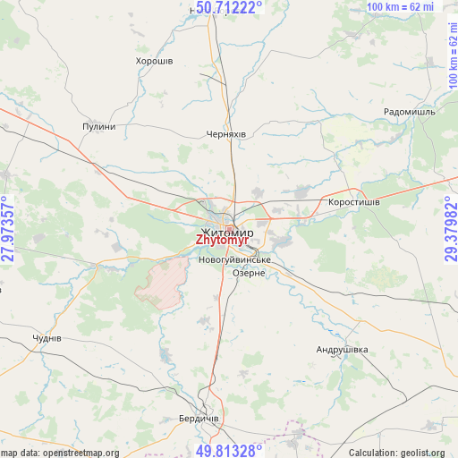
Zhytomyr GPS coordinates[2]
50° 15' 53.532" North, 28° 40' 36.084" East
| Map corner | latitude | longitude |
|---|---|---|
| Upper-left | 50.71222°, | 27.97357° |
| Center: | 50.26487°, | 28.67669° |
| Lower-right: | 49.81328°, | 29.37982° |
| Map W x H: | 100×100 km | = 62.1×62.1mi |
| max Lat: | 52.18903° ⇑12.7% North |
| Zhytomyr: | 50.26487° |
| min Lat: | ⇓87.3% South 44.39214° |
| min Long | Zhytomyr | max Long |
| 22.20555° | 28.67669° | 40.13222° |
| W 26%⇐ | ⇒74% E |
Elevation
Elevation of Zhytomyr is 228 m = 748 ft, and this is 72.2 m = 237 ft above average elevation for this country.
| Max E: |
886 m = 2907 ft | 24.3% |
| Zhytomyr | 228 m 748 ft | |
| Avg. | 155.8 m = 511 ft | |
Min E: |
-3 m = -10 ft | 75.7% |
See also: Zhytomyr elevation on elevation.city.
Geographical zone
Zhytomyr is located in North temperate zone (between Tropic of Cancer and the Arctic Circle). Distance of this North polar circle is 1812.2 km =1126 mi to North.| Distance of | km | miles | from Zhytomyr |
|---|---|---|---|
| North Pole | 4418.1 | 2745.3 | to North |
| Arctic Circle | 1812.2 | 1126 | to North |
| Tropic Cancer | 2983 | 1853.5 | to South |
| Equator | 5588.9 | 3472.8 | to South |


Nearby cities:
15 places around Zhytomyr: (largest is in red/bold)
• Andrushivka
36.4 km =22.6 mi,  137°
137°
• Berdychiv
41 km =25.5 mi,  187°
187°
• Bykivka
49.4 km =30.7 mi,  273°
273°
• Cherniakhiv
21.3 km =13.2 mi,  358°
358°
• Chervone
37.6 km =23.4 mi,  158°
158°
• Chudniv
46.3 km =28.8 mi,  239°
239°
• Denyshi
20.2 km =12.6 mi,  253°
253°
• Holovyne
25.2 km =15.7 mi,  24°
24°
• Hryshkivtsi
37 km =23 mi, 188°
• Khoroshiv
40.5 km =25.2 mi,  335°
335°
• Korostyshiv
27.6 km =17.1 mi,  77°
77°
• Nova Borova
47.7 km =29.6 mi, 356°
• Ozerne
10.5 km =6.5 mi, 157°
• Pulyny
36.6 km =22.7 mi,  308°
308°
• Radomyshl
46.9 km =29.1 mi,  56°
56°
In other languages:
- In France: Jytomyr
- In German: Schytomyr
- In Italian: Žytomyr
- In Russian: Житомир
- In Chinese: 日托米尔
Sources, notices
• [Note1] Compared only with cities in Ukraine existing in our database
• [Src1] Map data: © OpenStreetMap contributors (CC-BY-SA)
• [Src2] Other city data from geonames.org with taken over terms of usage.
• [Src3] Geographical zone / Annual Mean Temperature by Robert A. Rohde @ Wikipedia
