Andrushivka geodata
Andrushivka (Zhytomyr) is a seat of a second-order administrative division; located in Ukraine in Europe/Kiev (GMT+3) time zone. With population of 9,522 people, there are 374 cities with bigger population in this country. Compared to other cities in Ukraine, 84.1% of cities are located further ↓South; 72.5% of cities are located further →East and 71.5% of cities have lower elevation than Andrushivka. Note1


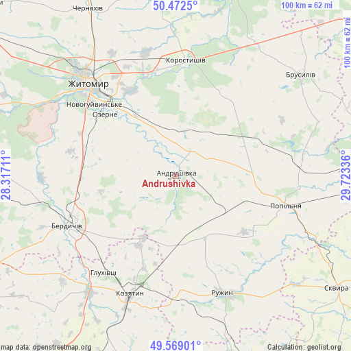
Andrushivka GPS coordinates[2]
50° 1' 22.368" North, 29° 1' 12.828" East
| Map corner | latitude | longitude |
|---|---|---|
| Upper-left | 50.4725°, | 28.31711° |
| Center: | 50.02288°, | 29.02023° |
| Lower-right: | 49.56901°, | 29.72336° |
| Map W x H: | 100.5×100.5 km | = 62.4×62.4mi |
| max Lat: | 52.18903° ⇑15.9% North |
| Andrushivka: | 50.02288° |
| min Lat: | ⇓84.1% South 44.39214° |
| min Long | Andrushivka | max Long |
| 22.20555° | 29.02023° | 40.13222° |
| W 27.5%⇐ | ⇒72.5% E |
Elevation
Elevation of Andrushivka is 212 m = 696 ft, and this is 56.2 m = 184 ft above average elevation for this country.
| Max E: |
886 m = 2907 ft | 28.5% |
| Andrushivka | 212 m 696 ft | |
| Avg. | 155.8 m = 511 ft | |
Min E: |
-3 m = -10 ft | 71.5% |
See also: Ukraine elevation on elevation.city.
Geographical zone
Andrushivka is located in North temperate zone (between Tropic of Cancer and the Arctic Circle). Distance of this North polar circle is 1839.2 km =1142.8 mi to North.| Distance of | km | miles | from Andrushivka |
|---|---|---|---|
| North Pole | 4445 | 2762 | to North |
| Arctic Circle | 1839.2 | 1142.8 | to North |
| Tropic Cancer | 2956.1 | 1836.8 | to South |
| Equator | 5562 | 3456.1 | to South |


Nearby cities:
15 places around Andrushivka: (largest is in red/bold)
• Andrushky
27.9 km =17.3 mi,  124°
124°
• Berdychiv
32.9 km =20.4 mi,  245°
245°
• Brovky Pershi
16.2 km =10.1 mi,  128°
128°
• Bystriivka
27 km =16.8 mi,  139°
139°
• Chervone
13.5 km =8.4 mi,  233°
233°
• Chornorudka
19.8 km =12.3 mi,  171°
171°
• Derhanivka
37.1 km =23.1 mi,  175°
175°
• Hryshkivtsi
31.3 km =19.4 mi, 251°
• Korostyshiv
32.8 km =20.4 mi,  4°
4°
• Kozyatyn
36.8 km =22.9 mi,  201°
201°
• Kvitneve
36.7 km =22.8 mi,  96°
96°
• Ozerne
26.7 km =16.6 mi,  310°
310°
• Popilnia
31.9 km =19.8 mi, 104°
• Ruzhyn
35.9 km =22.3 mi,  158°
158°
• Zhytomyr
36.4 km =22.6 mi,  317°
317°
Sources, notices
• [Note1] Compared only with cities in Ukraine existing in our database
• [Src1] Map data: © OpenStreetMap contributors (CC-BY-SA)
• [Src2] Other city data from geonames.org with taken over terms of usage.
• [Src3] Geographical zone / Annual Mean Temperature by Robert A. Rohde @ Wikipedia
