Cherniakhiv geodata
Cherniakhiv (Zhytomyr) is a seat of a second-order administrative division; located in Ukraine in Europe/Kiev (GMT+3) time zone. With population of 10,082 people, there are 358 cities with bigger population in this country. Compared to other cities in Ukraine, 90.2% of cities are located further ↓South; 74.1% of cities are located further →East and 74.9% of cities have lower elevation than Cherniakhiv. Note1


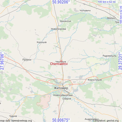
Cherniakhiv GPS coordinates[2]
50° 27' 23.472" North, 28° 40' 12.648" East
| Map corner | latitude | longitude |
|---|---|---|
| Upper-left | 50.90206°, | 27.96706° |
| Center: | 50.45652°, | 28.67018° |
| Lower-right: | 50.00675°, | 29.37331° |
| Map W x H: | 99.5×99.5 km | = 61.8×61.8mi |
| max Lat: | 52.18903° ⇑9.8% North |
| Cherniakhiv: | 50.45652° |
| min Lat: | ⇓90.2% South 44.39214° |
| min Long | Cherniakhiv | max Long |
| 22.20555° | 28.67018° | 40.13222° |
| W 25.9%⇐ | ⇒74.1% E |
Elevation
Elevation of Cherniakhiv is 226 m = 741 ft, and this is 70.2 m = 230 ft above average elevation for this country.
| Max E: |
886 m = 2907 ft | 25.1% |
| Cherniakhiv | 226 m 741 ft | |
| Avg. | 155.8 m = 511 ft | |
Min E: |
-3 m = -10 ft | 74.9% |
See also: Ukraine elevation on elevation.city.
Geographical zone
Cherniakhiv is located in North temperate zone (between Tropic of Cancer and the Arctic Circle). Distance of this North polar circle is 1790.9 km =1112.8 mi to North.| Distance of | km | miles | from Cherniakhiv |
|---|---|---|---|
| North Pole | 4396.8 | 2732 | to North |
| Arctic Circle | 1790.9 | 1112.8 | to North |
| Tropic Cancer | 3004.3 | 1866.8 | to South |
| Equator | 5610.2 | 3486 | to South |


Nearby cities:
15 places around Cherniakhiv: (largest is in red/bold)
• Andrushivka
54.3 km =33.7 mi,  152°
152°
• Bykivka
52 km =32.3 mi,  249°
249°
• Chopovychi
46.4 km =28.8 mi,  25°
25°
• Denyshi
32.9 km =20.4 mi,  215°
215°
• Dovbysh
49.3 km =30.6 mi,  259°
259°
• Holovyne
11.1 km =6.9 mi,  81°
81°
• Khoroshiv
22.5 km =14 mi,  314°
314°
• Korosten’
56 km =34.8 mi,  357°
357°
• Korostyshiv
31.5 km =19.6 mi,  119°
119°
• Malyn
53.3 km =33.1 mi,  48°
48°
• Nova Borova
26.4 km =16.4 mi,  354°
354°
• Ozerne
31.3 km =19.4 mi,  171°
171°
• Pulyny
28.3 km =17.6 mi,  272°
272°
• Radomyshl
39.8 km =24.7 mi, 83°
• Zhytomyr
21.3 km =13.2 mi,  178°
178°
Sources, notices
• [Note1] Compared only with cities in Ukraine existing in our database
• [Src1] Map data: © OpenStreetMap contributors (CC-BY-SA)
• [Src2] Other city data from geonames.org with taken over terms of usage.
• [Src3] Geographical zone / Annual Mean Temperature by Robert A. Rohde @ Wikipedia
