Ruska Poliana geodata
Ruska Poliana (Cherkasy) is a populated place; located in Ukraine in Europe/Kiev (GMT+3) time zone. With population of 7,780 people, there are 460 cities with bigger population in this country. Compared to other cities in Ukraine, 73.1% of cities are located further ↓South; 57.6% of cities are located further →East and 56.5% of cities have higher elevation than Ruska Poliana. Note1


Ruska Poliana GPS coordinates[2]
49° 25' 1.2" North, 31° 55' 12.324" East
| Map corner | latitude | longitude |
|---|---|---|
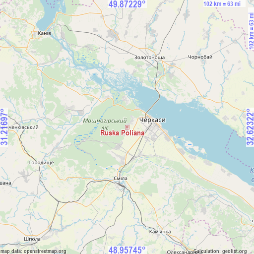
| Upper-left | 49.87229°, | 31.21697° |
| Center: | 49.417°, | 31.92009° |
| Lower-right: | 48.95745°, | 32.62322° |
| Map W x H: | 101.7×101.7 km | = 63.2×63.2mi |
| max Lat: | 52.18903° ⇑26.9% North |
| Ruska Poliana: | 49.417° |
| min Lat: | ⇓73.1% South 44.39214° |
| min Long | Ruska Poliana | max Long |
| 22.20555° | 31.92009° | 40.13222° |
| W 42.4%⇐ | ⇒57.6% E |
Elevation
Elevation of Ruska Poliana is 116 m = 381 ft, and this is 39.8 m = 131 ft below average elevation for this country.
| Max E: |
886 m = 2907 ft | 56.5% |
| Avg. | 155.8 m = 511 ft | |
| Ruska Poliana | 116 m = 381 ft | |
Min E: |
-3 m = -10 ft | 43.5% |
See also: Ukraine elevation on elevation.city.
Geographical zone
Ruska Poliana is located in North temperate zone (between Tropic of Cancer and the Arctic Circle). Distance of this North polar circle is 1906.5 km =1184.6 mi to North.| Distance of | km | miles | from Ruska Poliana |
|---|---|---|---|
| North Pole | 4512.4 | 2803.9 | to North |
| Arctic Circle | 1906.5 | 1184.6 | to North |
| Tropic Cancer | 2888.7 | 1795 | to South |
| Equator | 5494.7 | 3414.2 | to South |


Nearby cities:
15 places around Ruska Poliana: (largest is in red/bold)
• Cherkasy
10.3 km =6.4 mi,  82°
82°
• Chervona Sloboda
17.9 km =11.1 mi,  105°
105°
• Chornobay
40.5 km =25.2 mi,  46°
46°
• Horodyshche
37.4 km =23.2 mi,  246°
246°
• Kamianka
44.9 km =27.9 mi,  162°
162°
• Kaniv
49.9 km =31 mi,  318°
318°
• Kapitanivka
57.5 km =35.7 mi,  194°
194°
• Korsun-Shevchenkivskyi
47.8 km =29.7 mi,  270°
270°
• Lebedyn
58.1 km =36.1 mi,  209°
209°
• Mliiv
30.5 km =19 mi, 253°
• Moshny
18.1 km =11.2 mi,  312°
312°
• Oleksandrivka
55.4 km =34.4 mi, 155°
• Smila
21.8 km =13.5 mi, 186°
• Tsvitkove
40.5 km =25.2 mi,  223°
223°
• Zolotonosha
29.3 km =18.2 mi,  17°
17°
Sources, notices
• [Note1] Compared only with cities in Ukraine existing in our database
• [Src1] Map data: © OpenStreetMap contributors (CC-BY-SA)
• [Src2] Other city data from geonames.org with taken over terms of usage.
• [Src3] Geographical zone / Annual Mean Temperature by Robert A. Rohde @ Wikipedia
