Kirovs’k geodata
Kirovs’k (Luhansk) is a populated place; located in Ukraine in Europe/Zaporozhye (GMT+3) time zone. With population of 40,000 people, there are 112 cities with bigger population in this country. Compared to other cities in Ukraine, 58.6% of cities are located further ↓South; 97.4% of cities are located further ←West and 67.5% of cities have lower elevation than Kirovs’k. Note1


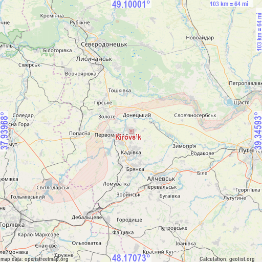
Kirovs’k GPS coordinates[2]
48° 38' 15.036" North, 38° 38' 34.08" East
| Map corner | latitude | longitude |
|---|---|---|
| Upper-left | 49.10001°, | 37.93968° |
| Center: | 48.63751°, | 38.6428° |
| Lower-right: | 48.17073°, | 39.34593° |
| Map W x H: | 103.3×103.3 km | = 64.2×64.2mi |
| max Lat: | 52.18903° ⇑41.4% North |
| Kirovs’k: | 48.63751° |
| min Lat: | ⇓58.6% South 44.39214° |
| min Long | Kirovs’k | max Long |
| 22.20555° | 38.6428° | 40.13222° |
| W 97.4%⇐ | ⇒2.6% E |
Elevation
Elevation of Kirovs’k is 196 m = 643 ft, and this is 40.2 m = 132 ft above average elevation for this country.
| Max E: |
886 m = 2907 ft | 32.5% |
| Kirovs’k | 196 m 643 ft | |
| Avg. | 155.8 m = 511 ft | |
Min E: |
-3 m = -10 ft | 67.5% |
See also: Kirovs’k elevation on elevation.city.
Geographical zone
Kirovs’k is located in North temperate zone (between Tropic of Cancer and the Arctic Circle). Distance of this North polar circle is 1993.2 km =1238.5 mi to North.| Distance of | km | miles | from Kirovs’k |
|---|---|---|---|
| North Pole | 4599.1 | 2857.7 | to North |
| Arctic Circle | 1993.2 | 1238.5 | to North |
| Tropic Cancer | 2802.1 | 1741.1 | to South |
| Equator | 5408 | 3360.4 | to South |


Nearby cities:
15 places around Kirovs’k: (largest is in red/bold)
• Alchevs’k
22.7 km =14.1 mi,  145°
145°
• Artemivs’k
22.9 km =14.2 mi,  163°
163°
• Bayrachky
27.5 km =17.1 mi,  186°
186°
• Bryanka
14.2 km =8.8 mi,  171°
171°
• Hirs’ke
15.3 km =9.5 mi,  314°
314°
• Kadiyivka
7.7 km =4.8 mi,  179°
179°
• Pereval’s’k
26.7 km =16.6 mi, 146°
• Pervomays’k
7 km =4.3 mi,  263°
263°
• Popasna
19.5 km =12.1 mi,  268°
268°
• Slov`yanoserbsk
25.7 km =16 mi,  74°
74°
• Toshkivka
16.4 km =10.2 mi,  343°
343°
• Tr’okhizbenka
27 km =16.8 mi,  60°
60°
• Voronove
29.4 km =18.3 mi,  349°
349°
• Zoryns’k
25.1 km =15.6 mi, 183°
• Zymohiria
22.4 km =13.9 mi,  105°
105°
Sources, notices
• [Note1] Compared only with cities in Ukraine existing in our database
• [Src1] Map data: © OpenStreetMap contributors (CC-BY-SA)
• [Src2] Other city data from geonames.org with taken over terms of usage.
• [Src3] Geographical zone / Annual Mean Temperature by Robert A. Rohde @ Wikipedia
