Tulchyn geodata
Tulchyn (Vinnyts'ka) is a seat of a second-order administrative division; located in Ukraine in Europe/Kiev (GMT+3) time zone. With population of 16,136 people, there are 240 cities with bigger population in this country. Compared to other cities in Ukraine, 59.7% of cities are located further ↓South; 73.2% of cities are located further →East and 76.3% of cities have lower elevation than Tulchyn. Note1


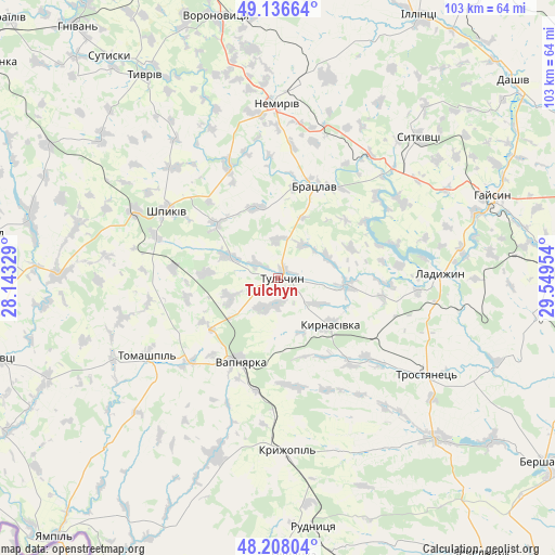
Tulchyn GPS coordinates[2]
48° 40' 28.128" North, 28° 50' 47.076" East
| Map corner | latitude | longitude |
|---|---|---|
| Upper-left | 49.13664°, | 28.14329° |
| Center: | 48.67448°, | 28.84641° |
| Lower-right: | 48.20804°, | 29.54954° |
| Map W x H: | 103.3×103.2 km | = 64.2×64.1mi |
| max Lat: | 52.18903° ⇑40.3% North |
| Tulchyn: | 48.67448° |
| min Lat: | ⇓59.7% South 44.39214° |
| min Long | Tulchyn | max Long |
| 22.20555° | 28.84641° | 40.13222° |
| W 26.8%⇐ | ⇒73.2% E |
Elevation
Elevation of Tulchyn is 231 m = 758 ft, and this is 75.2 m = 247 ft above average elevation for this country.
| Max E: |
886 m = 2907 ft | 23.7% |
| Tulchyn | 231 m 758 ft | |
| Avg. | 155.8 m = 511 ft | |
Min E: |
-3 m = -10 ft | 76.3% |
See also: Ukraine elevation on elevation.city.
Geographical zone
Tulchyn is located in North temperate zone (between Tropic of Cancer and the Arctic Circle). Distance of this North polar circle is 1989.1 km =1236 mi to North.| Distance of | km | miles | from Tulchyn |
|---|---|---|---|
| North Pole | 4595 | 2855.2 | to North |
| Arctic Circle | 1989.1 | 1236 | to North |
| Tropic Cancer | 2806.2 | 1743.7 | to South |
| Equator | 5412.1 | 3362.9 | to South |


Nearby cities:
15 places around Tulchyn: (largest is in red/bold)
• Bratslav
17.9 km =11.1 mi,  22°
22°
• Haisyn
42.7 km =26.5 mi,  69°
69°
• Klembivka
45 km =28 mi,  225°
225°
• Kryzhopil’
32.5 km =20.2 mi,  177°
177°
• Ladyzhyn
28.7 km =17.8 mi,  87°
87°
• Murafa
47.4 km =29.5 mi,  282°
282°
• Nemyriv
32.9 km =20.4 mi,  358°
358°
• Obodivka
42.1 km =26.2 mi,  135°
135°
• Tomashpil’
28.3 km =17.6 mi,  238°
238°
• Torkanivka
44.8 km =27.8 mi,  150°
150°
• Trostyanets’
33.9 km =21.1 mi,  122°
122°
• Tsybulevka
37.1 km =23.1 mi, 149°
• Tyvriv
45.1 km =28 mi,  326°
326°
• Vapnyarka
17.3 km =10.7 mi,  205°
205°
• Voronovytsya
49.9 km =31 mi,  345°
345°
Sources, notices
• [Note1] Compared only with cities in Ukraine existing in our database
• [Src1] Map data: © OpenStreetMap contributors (CC-BY-SA)
• [Src2] Other city data from geonames.org with taken over terms of usage.
• [Src3] Geographical zone / Annual Mean Temperature by Robert A. Rohde @ Wikipedia
