Sokyryany geodata
Sokyryany (Chernivtsi Oblast') is a seat of a second-order administrative division; located in Ukraine in Europe/Kiev (GMT+3) time zone. With population of 9,192 people, there are 392 cities with bigger population in this country. Compared to other cities in Ukraine, 54.2% of cities are located further ↓South; 77.3% of cities are located further →East and 74.4% of cities have lower elevation than Sokyryany. Note1


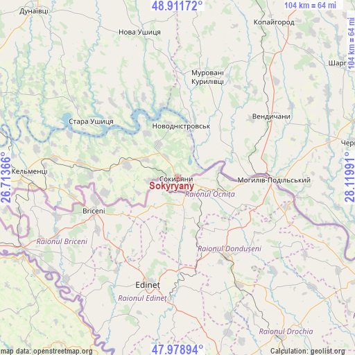
Sokyryany GPS coordinates[2]
48° 26' 50.892" North, 27° 25' 0.408" East
| Map corner | latitude | longitude |
|---|---|---|
| Upper-left | 48.91172°, | 26.71366° |
| Center: | 48.44747°, | 27.41678° |
| Lower-right: | 47.97894°, | 28.11991° |
| Map W x H: | 103.7×103.7 km | = 64.4×64.4mi |
| max Lat: | 52.18903° ⇑45.8% North |
| Sokyryany: | 48.44747° |
| min Lat: | ⇓54.2% South 44.39214° |
| min Long | Sokyryany | max Long |
| 22.20555° | 27.41678° | 40.13222° |
| W 22.7%⇐ | ⇒77.3% E |
Elevation
Elevation of Sokyryany is 223 m = 732 ft, and this is 67.2 m = 220 ft above average elevation for this country.
| Max E: |
886 m = 2907 ft | 25.6% |
| Sokyryany | 223 m 732 ft | |
| Avg. | 155.8 m = 511 ft | |
Min E: |
-3 m = -10 ft | 74.4% |
See also: Ukraine elevation on elevation.city.
Geographical zone
Sokyryany is located in North temperate zone (between Tropic of Cancer and the Arctic Circle). Distance of this North polar circle is 2014.3 km =1251.6 mi to North.| Distance of | km | miles | from Sokyryany |
|---|---|---|---|
| North Pole | 4620.2 | 2870.9 | to North |
| Arctic Circle | 2014.3 | 1251.6 | to North |
| Tropic Cancer | 2780.9 | 1728 | to South |
| Equator | 5386.9 | 3347.3 | to South |


Nearby cities:
15 places around Sokyryany: (largest is in red/bold)
• Chernivtsi
52.5 km =32.6 mi,  78°
78°
• Dunaivtsi
64.1 km =39.8 mi,  320°
320°
• Kamianets-Podilskyi
66.6 km =41.4 mi,  293°
293°
• Kel’mentsi
43 km =26.7 mi,  272°
272°
• Kopayhorod
53.6 km =33.3 mi,  31°
31°
• Makiv
65.8 km =40.9 mi,  305°
305°
• Mohyliv-Podilskyi
28.1 km =17.5 mi,  90°
90°
• Murovani Kurylivtsi
31.6 km =19.6 mi,  13°
13°
• Nova Ushytsya
44.6 km =27.7 mi,  346°
346°
• Novodnistrovs’k
15.2 km =9.4 mi, 6°
• Serebriya
22.3 km =13.9 mi, 87°
• Sharhorod
59.3 km =36.8 mi,  54°
54°
• Smotrych
67.4 km =41.9 mi, 290°
• Vendychany
33.2 km =20.6 mi,  56°
56°
• Vinkivtsi
66.6 km =41.4 mi, 348°
Sources, notices
• [Note1] Compared only with cities in Ukraine existing in our database
• [Src1] Map data: © OpenStreetMap contributors (CC-BY-SA)
• [Src2] Other city data from geonames.org with taken over terms of usage.
• [Src3] Geographical zone / Annual Mean Temperature by Robert A. Rohde @ Wikipedia
