Buchmany geodata
Buchmany (Zhytomyr) is a populated place; located in Ukraine in Europe/Kiev (GMT+3) time zone. With population of 792 people, there are 1489 cities with bigger population in this country. Compared to other cities in Ukraine, 96% of cities are located further ↓South; 75.8% of cities are located further →East and 68.2% of cities have lower elevation than Buchmany. Note1


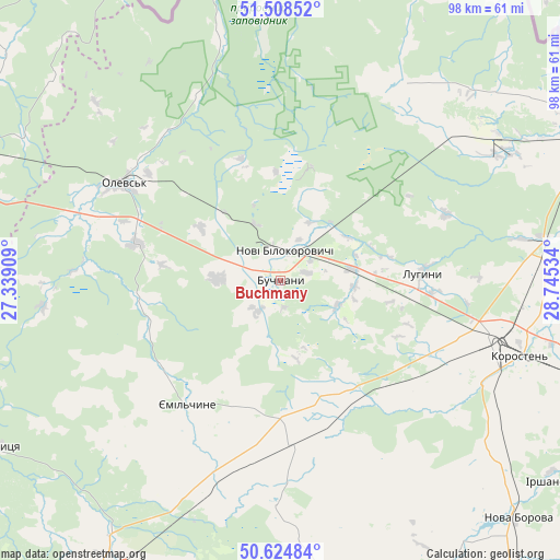
Buchmany GPS coordinates[2]
51° 4' 7.644" North, 28° 2' 31.956" East
| Map corner | latitude | longitude |
|---|---|---|
| Upper-left | 51.50852°, | 27.33909° |
| Center: | 51.06879°, | 28.04221° |
| Lower-right: | 50.62484°, | 28.74534° |
| Map W x H: | 98.3×98.3 km | = 61.1×61.1mi |
| max Lat: | 52.18903° ⇑4% North |
| Buchmany: | 51.06879° |
| min Lat: | ⇓96% South 44.39214° |
| min Long | Buchmany | max Long |
| 22.20555° | 28.04221° | 40.13222° |
| W 24.2%⇐ | ⇒75.8% E |
Elevation
Elevation of Buchmany is 199 m = 653 ft, and this is 43.2 m = 142 ft above average elevation for this country.
| Max E: |
886 m = 2907 ft | 31.8% |
| Buchmany | 199 m 653 ft | |
| Avg. | 155.8 m = 511 ft | |
Min E: |
-3 m = -10 ft | 68.2% |
See also: Ukraine elevation on elevation.city.
Geographical zone
Buchmany is located in North temperate zone (between Tropic of Cancer and the Arctic Circle). Distance of this North polar circle is 1722.9 km =1070.6 mi to North.| Distance of | km | miles | from Buchmany |
|---|---|---|---|
| North Pole | 4328.7 | 2689.7 | to North |
| Arctic Circle | 1722.9 | 1070.6 | to North |
| Tropic Cancer | 3072.4 | 1909.1 | to South |
| Equator | 5678.3 | 3528.3 | to South |


Nearby cities:
15 places around Buchmany: (largest is in red/bold)
• Chopovychi
69 km =42.9 mi,  112°
112°
• Druzhba
14 km =8.7 mi,  340°
340°
• Horodnytsya
58.6 km =36.4 mi,  240°
240°
• Khoroshiv
59.5 km =37 mi,  151°
151°
• Korosten’
43.5 km =27 mi, 106°
• Luhyny
25.1 km =15.6 mi,  86°
86°
• Nova Borova
58.9 km =36.6 mi,  135°
135°
• Novi Bilokorovychi
5.3 km =3.3 mi,  9°
9°
• Novohrad-Volynskyi
60.7 km =37.7 mi,  209°
209°
• Olevs’k
32.3 km =20.1 mi,  302°
302°
• Ovruch
60.2 km =37.4 mi,  61°
61°
• Pershotravneve
67.9 km =42.2 mi, 57°
• Pulyny
68.7 km =42.7 mi,  166°
166°
• Rokytne
62.3 km =38.7 mi,  292°
292°
• Yemil’chyne
27.3 km =17 mi,  217°
217°
Sources, notices
• [Note1] Compared only with cities in Ukraine existing in our database
• [Src1] Map data: © OpenStreetMap contributors (CC-BY-SA)
• [Src2] Other city data from geonames.org with taken over terms of usage.
• [Src3] Geographical zone / Annual Mean Temperature by Robert A. Rohde @ Wikipedia
