Yemil’chyne geodata
Yemil’chyne (Zhytomyr) is a seat of a second-order administrative division; located in Ukraine in Europe/Kiev (GMT+3) time zone. In our database, there are 1661 cities with bigger population. Compared to other cities in Ukraine, 95% of cities are located further ↓South; 76.2% of cities are located further →East and 68.9% of cities have lower elevation than Yemil’chyne. Note1


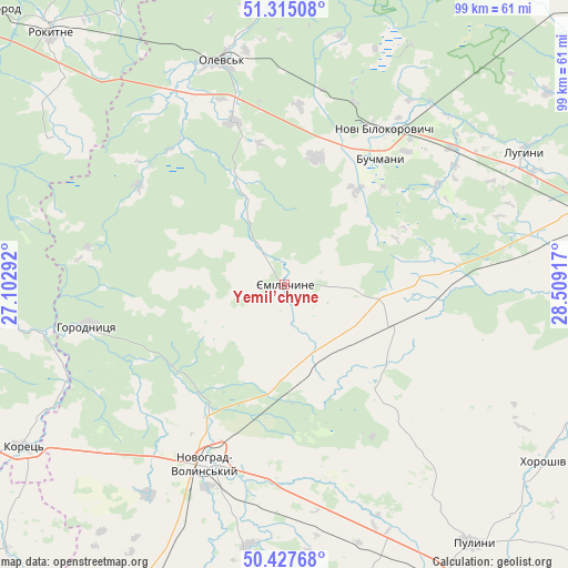
Yemil’chyne GPS coordinates[2]
50° 52' 24.564" North, 27° 48' 21.744" East
| Map corner | latitude | longitude |
|---|---|---|
| Upper-left | 51.31508°, | 27.10292° |
| Center: | 50.87349°, | 27.80604° |
| Lower-right: | 50.42768°, | 28.50917° |
| Map W x H: | 98.7×98.7 km | = 61.3×61.3mi |
| max Lat: | 52.18903° ⇑5% North |
| Yemil’chyne: | 50.87349° |
| min Lat: | ⇓95% South 44.39214° |
| min Long | Yemil’chyne | max Long |
| 22.20555° | 27.80604° | 40.13222° |
| W 23.8%⇐ | ⇒76.2% E |
Elevation
Elevation of Yemil’chyne is 201 m = 659 ft, and this is 45.2 m = 148 ft above average elevation for this country.
| Max E: |
886 m = 2907 ft | 31.1% |
| Yemil’chyne | 201 m 659 ft | |
| Avg. | 155.8 m = 511 ft | |
Min E: |
-3 m = -10 ft | 68.9% |
See also: Ukraine elevation on elevation.city.
Geographical zone
Yemil’chyne is located in North temperate zone (between Tropic of Cancer and the Arctic Circle). Distance of this North polar circle is 1744.6 km =1084 mi to North.| Distance of | km | miles | from Yemil’chyne |
|---|---|---|---|
| North Pole | 4350.5 | 2703.3 | to North |
| Arctic Circle | 1744.6 | 1084 | to North |
| Tropic Cancer | 3050.7 | 1895.6 | to South |
| Equator | 5656.6 | 3514.8 | to South |


Nearby cities:
15 places around Yemil’chyne: (largest is in red/bold)
• Buchmany
27.3 km =17 mi,  37°
37°
• Dovbysh
57.1 km =35.5 mi,  167°
167°
• Druzhba
36.9 km =22.9 mi,  18°
18°
• Horodnytsya
35.1 km =21.8 mi,  257°
257°
• Hubkiv
53.6 km =33.3 mi, 264°
• Khoroshiv
54.3 km =33.7 mi,  124°
124°
• Koloniya Zastav’ye
54.6 km =33.9 mi, 263°
• Korets
53.7 km =33.4 mi,  237°
237°
• Korosten’
59.1 km =36.7 mi,  80°
80°
• Luhyny
47.6 km =29.6 mi,  60°
60°
• Novi Bilokorovychi
32 km =19.9 mi,  32°
32°
• Novohrad-Volynskyi
33.8 km =21 mi,  203°
203°
• Olevs’k
40.5 km =25.2 mi,  344°
344°
• Pulyny
55.8 km =34.7 mi,  143°
143°
• Rokytne
61.2 km =38 mi,  317°
317°
Sources, notices
• [Note1] Compared only with cities in Ukraine existing in our database
• [Src1] Map data: © OpenStreetMap contributors (CC-BY-SA)
• [Src2] Other city data from geonames.org with taken over terms of usage.
• [Src3] Geographical zone / Annual Mean Temperature by Robert A. Rohde @ Wikipedia
