Olevs’k geodata
Olevs’k (Zhytomyr) is a seat of a second-order administrative division; located in Ukraine in Europe/Kiev (GMT+3) time zone. In our database, there are 1661 cities with bigger population. Compared to other cities in Ukraine, 97% of cities are located further ↓South; 76.7% of cities are located further →East and 63.1% of cities have lower elevation than Olevs’k. Note1


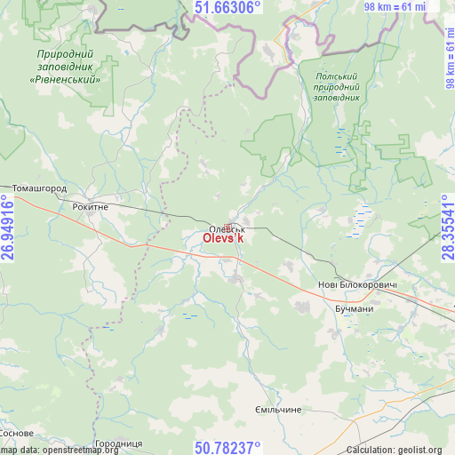
Olevs’k GPS coordinates[2]
51° 13' 29.352" North, 27° 39' 8.208" East
| Map corner | latitude | longitude |
|---|---|---|
| Upper-left | 51.66306°, | 26.94916° |
| Center: | 51.22482°, | 27.65228° |
| Lower-right: | 50.78237°, | 28.35541° |
| Map W x H: | 97.9×97.9 km | = 60.8×60.8mi |
| max Lat: | 52.18903° ⇑3% North |
| Olevs’k: | 51.22482° |
| min Lat: | ⇓97% South 44.39214° |
| min Long | Olevs’k | max Long |
| 22.20555° | 27.65228° | 40.13222° |
| W 23.3%⇐ | ⇒76.7% E |
Elevation
Elevation of Olevs’k is 180 m = 591 ft, and this is 24.2 m = 79 ft above average elevation for this country.
| Max E: |
886 m = 2907 ft | 36.9% |
| Olevs’k | 180 m 591 ft | |
| Avg. | 155.8 m = 511 ft | |
Min E: |
-3 m = -10 ft | 63.1% |
See also: Ukraine elevation on elevation.city.
Geographical zone
Olevs’k is located in North temperate zone (between Tropic of Cancer and the Arctic Circle). Distance of this North polar circle is 1705.5 km =1059.7 mi to North.| Distance of | km | miles | from Olevs’k |
|---|---|---|---|
| North Pole | 4311.4 | 2679 | to North |
| Arctic Circle | 1705.5 | 1059.7 | to North |
| Tropic Cancer | 3089.7 | 1919.8 | to South |
| Equator | 5695.7 | 3539.1 | to South |


Nearby cities:
15 places around Olevs’k: (largest is in red/bold)
• Berezne
67.7 km =42.1 mi,  248°
248°
• Buchmany
32.3 km =20.1 mi,  122°
122°
• Druzhba
22.8 km =14.2 mi,  100°
100°
• Horodnytsya
52.1 km =32.4 mi,  206°
206°
• Hubkiv
61.2 km =38 mi,  223°
223°
• Koloniya Zastav’ye
62.7 km =39 mi, 223°
• Korets
75.9 km =47.2 mi, 207°
• Korosten’
74.9 km =46.5 mi,  113°
113°
• Luhyny
54.5 km =33.9 mi, 106°
• Novi Bilokorovychi
30.6 km =19 mi, 113°
• Novohrad-Volynskyi
70.2 km =43.6 mi,  182°
182°
• Ovruch
80.8 km =50.2 mi,  82°
82°
• Rokytne
31.1 km =19.3 mi,  281°
281°
• Sarny
74.1 km =46 mi, 279°
• Yemil’chyne
40.5 km =25.2 mi,  164°
164°
Sources, notices
• [Note1] Compared only with cities in Ukraine existing in our database
• [Src1] Map data: © OpenStreetMap contributors (CC-BY-SA)
• [Src2] Other city data from geonames.org with taken over terms of usage.
• [Src3] Geographical zone / Annual Mean Temperature by Robert A. Rohde @ Wikipedia
