Putyla geodata
Putyla (Chernivtsi Oblast') is a seat of a second-order administrative division; located in Ukraine in Europe/Kiev (GMT+3) time zone. In our database, there are 1661 cities with bigger population. Compared to other cities in Ukraine, 56.7% of cities are located further ↑North; 85.7% of cities are located further →East and 99.3% of cities have lower elevation than Putyla. Note1


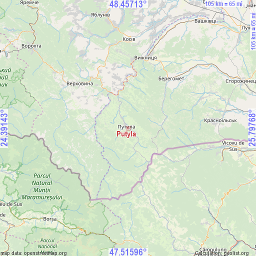
Putyla GPS coordinates[2]
47° 59' 19.284" North, 25° 5' 40.38" East
| Map corner | latitude | longitude |
|---|---|---|
| Upper-left | 48.45713°, | 24.39143° |
| Center: | 47.98869°, | 25.09455° |
| Lower-right: | 47.51596°, | 25.79768° |
| Map W x H: | 104.6×104.6 km | = 65×65mi |
| max Lat: | 52.18903° ⇑56.7% North |
| Putyla: | 47.98869° |
| min Lat: | ⇓43.3% South 44.39214° |
| min Long | Putyla | max Long |
| 22.20555° | 25.09455° | 40.13222° |
| W 14.3%⇐ | ⇒85.7% E |
Elevation
Elevation of Putyla is 629 m = 2064 ft, and this is 473.2 m = 1552 ft above average elevation for this country.
| Max E: |
886 m = 2907 ft | 0.7% |
| Putyla | 629 m 2064 ft | |
| Avg. | 155.8 m = 511 ft | |
Min E: |
-3 m = -10 ft | 99.3% |
See also: Ukraine elevation on elevation.city.
Geographical zone
Putyla is located in North temperate zone (between Tropic of Cancer and the Arctic Circle). Distance of this North polar circle is 2065.3 km =1283.3 mi to North.| Distance of | km | miles | from Putyla |
|---|---|---|---|
| North Pole | 4671.2 | 2902.5 | to North |
| Arctic Circle | 2065.3 | 1283.3 | to North |
| Tropic Cancer | 2729.9 | 1696.3 | to South |
| Equator | 5335.8 | 3315.5 | to South |


Nearby cities:
15 places around Putyla: (largest is in red/bold)
• Berehomet
28.3 km =17.6 mi,  41°
41°
• Chudey
39.9 km =24.8 mi,  79°
79°
• Davydivka
37.9 km =23.5 mi,  67°
67°
• Ispas
36.8 km =22.9 mi,  21°
21°
• Kosiv
35.8 km =22.2 mi,  0°
0°
• Krivopol’ye
37.4 km =23.2 mi,  307°
307°
• Kuty
30.7 km =19.1 mi,  11°
11°
• Myhove
28.3 km =17.6 mi,  48°
48°
• Rechka
34.6 km =21.5 mi,  339°
339°
• Sheshory
39.1 km =24.3 mi,  347°
347°
• Stari Kuty
31.9 km =19.8 mi, 10°
• Verkhniy Yasenov
22.2 km =13.8 mi,  330°
330°
• Verkhovyna
29.2 km =18.1 mi, 309°
• Vyzhnytsya
29.8 km =18.5 mi, 14°
• Yizhivtsi
42.6 km =26.5 mi, 82°
Sources, notices
• [Note1] Compared only with cities in Ukraine existing in our database
• [Src1] Map data: © OpenStreetMap contributors (CC-BY-SA)
• [Src2] Other city data from geonames.org with taken over terms of usage.
• [Src3] Geographical zone / Annual Mean Temperature by Robert A. Rohde @ Wikipedia
