Kupjansk geodata
Kupjansk (Kharkiv) is a seat of a second-order administrative division; located in Ukraine in Europe/Kiev (GMT+3) time zone. With population of 32,449 people, there are 135 cities with bigger population in this country. Compared to other cities in Ukraine, 78.1% of cities are located further ↓South; 92.9% of cities are located further ←West and 64.7% of cities have higher elevation than Kupjansk. Note1


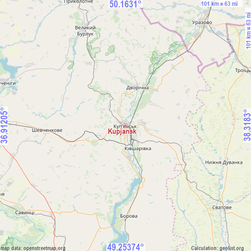
Kupjansk GPS coordinates[2]
49° 42' 37.98" North, 37° 36' 54.612" East
| Map corner | latitude | longitude |
|---|---|---|
| Upper-left | 50.1631°, | 36.91205° |
| Center: | 49.71055°, | 37.61517° |
| Lower-right: | 49.25374°, | 38.3183° |
| Map W x H: | 101.1×101.1 km | = 62.8×62.8mi |
| max Lat: | 52.18903° ⇑21.9% North |
| Kupjansk: | 49.71055° |
| min Lat: | ⇓78.1% South 44.39214° |
| min Long | Kupjansk | max Long |
| 22.20555° | 37.61517° | 40.13222° |
| W 92.9%⇐ | ⇒7.1% E |
Elevation
Elevation of Kupjansk is 92 m = 302 ft, and this is 63.8 m = 209 ft below average elevation for this country.
| Max E: |
886 m = 2907 ft | 64.7% |
| Avg. | 155.8 m = 511 ft | |
| Kupjansk | 92 m = 302 ft | |
Min E: |
-3 m = -10 ft | 35.3% |
See also: Ukraine elevation on elevation.city.
Geographical zone
Kupjansk is located in North temperate zone (between Tropic of Cancer and the Arctic Circle). Distance of this North polar circle is 1873.9 km =1164.4 mi to North.| Distance of | km | miles | from Kupjansk |
|---|---|---|---|
| North Pole | 4479.8 | 2783.6 | to North |
| Arctic Circle | 1873.9 | 1164.4 | to North |
| Tropic Cancer | 2921.4 | 1815.3 | to South |
| Equator | 5527.3 | 3434.5 | to South |


Nearby cities:
15 places around Kupjansk: (largest is in red/bold)
• Balakliya
61 km =37.9 mi,  243°
243°
• Borova
37 km =23 mi,  179°
179°
• Chervonyy Oskil
60.7 km =37.7 mi,  193°
193°
• Dvorichna
16.3 km =10.1 mi,  17°
17°
• Izyum
61.8 km =38.4 mi,  205°
205°
• Kivsharivka
10.3 km =6.4 mi,  149°
149°
• Nyzhnya Duvanka
42.6 km =26.5 mi,  109°
109°
• Pechenihy
52 km =32.3 mi,  290°
290°
• Prykolotne
53.9 km =33.5 mi,  338°
338°
• Savyntsi
52.5 km =32.6 mi,  229°
229°
• Shevchenkove
31.8 km =19.8 mi,  267°
267°
• Svatove
51 km =31.7 mi,  130°
130°
• Troyits’ke
53.6 km =33.3 mi,  64°
64°
• Velykyy Burluk
42.4 km =26.3 mi, 336°
• Yats’kivka
59.4 km =36.9 mi, 186°
Sources, notices
• [Note1] Compared only with cities in Ukraine existing in our database
• [Src1] Map data: © OpenStreetMap contributors (CC-BY-SA)
• [Src2] Other city data from geonames.org with taken over terms of usage.
• [Src3] Geographical zone / Annual Mean Temperature by Robert A. Rohde @ Wikipedia
