Obertyn geodata
Obertyn (Ivano-Frankivsk) is a populated place; located in Ukraine in Europe/Kiev (GMT+3) time zone. With population of 3,264 people, there are 875 cities with bigger population in this country. Compared to other cities in Ukraine, 60.4% of cities are located further ↓South; 85.2% of cities are located further →East and 88% of cities have lower elevation than Obertyn. Note1


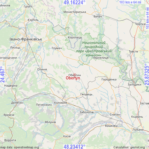
Obertyn GPS coordinates[2]
48° 42' 1.152" North, 25° 10' 12.432" East
| Map corner | latitude | longitude |
|---|---|---|
| Upper-left | 49.16224°, | 24.467° |
| Center: | 48.70032°, | 25.17012° |
| Lower-right: | 48.23412°, | 25.87325° |
| Map W x H: | 103.2×103.2 km | = 64.1×64.1mi |
| max Lat: | 52.18903° ⇑39.6% North |
| Obertyn: | 48.70032° |
| min Lat: | ⇓60.4% South 44.39214° |
| min Long | Obertyn | max Long |
| 22.20555° | 25.17012° | 40.13222° |
| W 14.8%⇐ | ⇒85.2% E |
Elevation
Elevation of Obertyn is 294 m = 965 ft, and this is 138.2 m = 453 ft above average elevation for this country.
| Max E: |
886 m = 2907 ft | 12% |
| Obertyn | 294 m 965 ft | |
| Avg. | 155.8 m = 511 ft | |
Min E: |
-3 m = -10 ft | 88% |
See also: Ukraine elevation on elevation.city.
Geographical zone
Obertyn is located in North temperate zone (between Tropic of Cancer and the Arctic Circle). Distance of this North polar circle is 1986.2 km =1234.2 mi to North.| Distance of | km | miles | from Obertyn |
|---|---|---|---|
| North Pole | 4592.1 | 2853.4 | to North |
| Arctic Circle | 1986.2 | 1234.2 | to North |
| Tropic Cancer | 2809 | 1745.4 | to South |
| Equator | 5415 | 3364.7 | to South |


Nearby cities:
15 places around Obertyn: (largest is in red/bold)
• Chernelytsya
22.4 km =13.9 mi,  56°
56°
• Chernyatyn
20.9 km =13 mi,  102°
102°
• Chornoliztsi
24.8 km =15.4 mi,  305°
305°
• Horodenka
24.5 km =15.2 mi, 97°
• Kolomyia
21.2 km =13.2 mi,  207°
207°
• Lanchyn
34.3 km =21.3 mi,  242°
242°
• Nyrkiv
34 km =21.1 mi,  67°
67°
• Otyniya
23 km =14.3 mi,  280°
280°
• Pechenizhyn
28.9 km =18 mi,  224°
224°
• Sadzhavka
31.8 km =19.8 mi, 241°
• Tlumach
21.9 km =13.6 mi,  326°
326°
• Tysmenytsya
32.7 km =20.3 mi, 313°
• Velykyy Klyuchiv
30.3 km =18.8 mi, 212°
• Zabolotiv
26.9 km =16.7 mi,  161°
161°
• Zolotyy Potik
26.4 km =16.4 mi,  28°
28°
Sources, notices
• [Note1] Compared only with cities in Ukraine existing in our database
• [Src1] Map data: © OpenStreetMap contributors (CC-BY-SA)
• [Src2] Other city data from geonames.org with taken over terms of usage.
• [Src3] Geographical zone / Annual Mean Temperature by Robert A. Rohde @ Wikipedia
