Oster geodata
Oster (Chernihiv) is a populated place; located in Ukraine in Europe/Kiev (GMT+3) time zone. With population of 6,794 people, there are 522 cities with bigger population in this country. Compared to other cities in Ukraine, 95.5% of cities are located further ↓South; 62.1% of cities are located further →East and 57.4% of cities have higher elevation than Oster. Note1


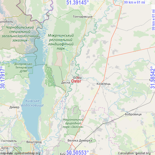
Oster GPS coordinates[2]
50° 57' 2.16" North, 30° 52' 56.244" East
| Map corner | latitude | longitude |
|---|---|---|
| Upper-left | 51.39145°, | 30.17917° |
| Center: | 50.9506°, | 30.88229° |
| Lower-right: | 50.50553°, | 31.58542° |
| Map W x H: | 98.5×98.5 km | = 61.2×61.2mi |
| max Lat: | 52.18903° ⇑4.5% North |
| Oster: | 50.9506° |
| min Lat: | ⇓95.5% South 44.39214° |
| min Long | Oster | max Long |
| 22.20555° | 30.88229° | 40.13222° |
| W 37.9%⇐ | ⇒62.1% E |
Elevation
Elevation of Oster is 114 m = 374 ft, and this is 41.8 m = 137 ft below average elevation for this country.
| Max E: |
886 m = 2907 ft | 57.4% |
| Avg. | 155.8 m = 511 ft | |
| Oster | 114 m = 374 ft | |
Min E: |
-3 m = -10 ft | 42.6% |
See also: Ukraine elevation on elevation.city.
Geographical zone
Oster is located in North temperate zone (between Tropic of Cancer and the Arctic Circle). Distance of this North polar circle is 1736 km =1078.7 mi to North.| Distance of | km | miles | from Oster |
|---|---|---|---|
| North Pole | 4341.9 | 2697.9 | to North |
| Arctic Circle | 1736 | 1078.7 | to North |
| Tropic Cancer | 3059.3 | 1901 | to South |
| Equator | 5665.2 | 3520.2 | to South |


Nearby cities:
15 places around Oster: (largest is in red/bold)
• Bobrovytsya
42.5 km =26.4 mi,  122°
122°
• Brovary
48.4 km =30.1 mi,  186°
186°
• Desna
8.9 km =5.5 mi,  253°
253°
• Dymer
44.6 km =27.7 mi, 245°
• Khotyanivka
45 km =28 mi,  209°
209°
• Kobyzhcha
45.7 km =28.4 mi,  107°
107°
• Kozelets’
17.3 km =10.7 mi,  103°
103°
• Liutizh
45.4 km =28.2 mi,  229°
229°
• Nosivka
49.1 km =30.5 mi,  92°
92°
• Novi Petrivtsi
47.4 km =29.5 mi,  220°
220°
• Olyshivka
43.7 km =27.2 mi,  46°
46°
• Pohreby
47.1 km =29.3 mi,  200°
200°
• Pukhivka
39.6 km =24.6 mi, 196°
• Semypolky
25.2 km =15.7 mi,  171°
171°
• Velyka Dymerka
39.8 km =24.7 mi,  177°
177°
Sources, notices
• [Note1] Compared only with cities in Ukraine existing in our database
• [Src1] Map data: © OpenStreetMap contributors (CC-BY-SA)
• [Src2] Other city data from geonames.org with taken over terms of usage.
• [Src3] Geographical zone / Annual Mean Temperature by Robert A. Rohde @ Wikipedia
