Kobyzhcha geodata
Kobyzhcha (Chernihiv) is a populated place; located in Ukraine in Europe/Kiev (GMT+3) time zone. With population of 4,332 people, there are 716 cities with bigger population in this country. Compared to other cities in Ukraine, 94.5% of cities are located further ↓South; 59.2% of cities are located further →East and 50.8% of cities have higher elevation than Kobyzhcha. Note1


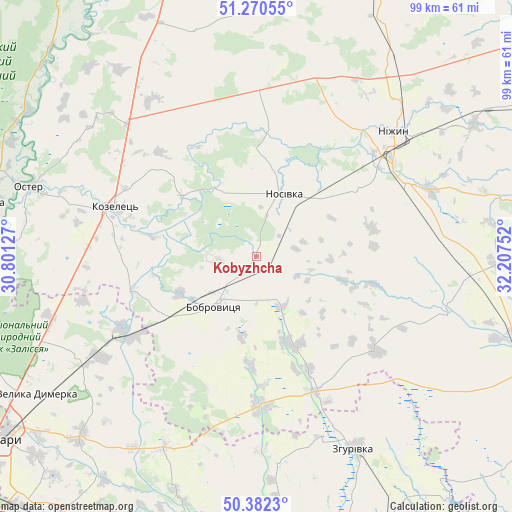
Kobyzhcha GPS coordinates[2]
50° 49' 42.744" North, 31° 30' 15.804" East
| Map corner | latitude | longitude |
|---|---|---|
| Upper-left | 51.27055°, | 30.80127° |
| Center: | 50.82854°, | 31.50439° |
| Lower-right: | 50.3823°, | 32.20752° |
| Map W x H: | 98.8×98.8 km | = 61.4×61.4mi |
| max Lat: | 52.18903° ⇑5.5% North |
| Kobyzhcha: | 50.82854° |
| min Lat: | ⇓94.5% South 44.39214° |
| min Long | Kobyzhcha | max Long |
| 22.20555° | 31.50439° | 40.13222° |
| W 40.8%⇐ | ⇒59.2% E |
Elevation
Elevation of Kobyzhcha is 131 m = 430 ft, and this is 24.8 m = 81 ft below average elevation for this country.
| Max E: |
886 m = 2907 ft | 50.8% |
| Avg. | 155.8 m = 511 ft | |
| Kobyzhcha | 131 m = 430 ft | |
Min E: |
-3 m = -10 ft | 49.2% |
See also: Ukraine elevation on elevation.city.
Geographical zone
Kobyzhcha is located in North temperate zone (between Tropic of Cancer and the Arctic Circle). Distance of this North polar circle is 1749.6 km =1087.2 mi to North.| Distance of | km | miles | from Kobyzhcha |
|---|---|---|---|
| North Pole | 4355.5 | 2706.4 | to North |
| Arctic Circle | 1749.6 | 1087.2 | to North |
| Tropic Cancer | 3045.7 | 1892.5 | to South |
| Equator | 5651.6 | 3511.7 | to South |


Nearby cities:
15 places around Kobyzhcha: (largest is in red/bold)
• Baryshivka
53.6 km =33.3 mi,  193°
193°
• Bobrovytsya
11.9 km =7.4 mi,  220°
220°
• Desna
53.3 km =33.1 mi,  281°
281°
• Korniyivka
45.9 km =28.5 mi,  183°
183°
• Kozelets’
28.5 km =17.7 mi,  289°
289°
• Kruty
49.4 km =30.7 mi,  58°
58°
• Kunashëvka
42.8 km =26.6 mi, 56°
• Nizhyn
36.2 km =22.5 mi,  47°
47°
• Nosivka
12.7 km =7.9 mi,  25°
25°
• Olyshivka
45.4 km =28.2 mi,  344°
344°
• Oster
45.7 km =28.4 mi, 287°
• Semypolky
41.7 km =25.9 mi,  254°
254°
• Talalayivka
32.6 km =20.3 mi, 63°
• Velyka Dymerka
49.8 km =30.9 mi,  238°
238°
• Zgurovka
41.3 km =25.7 mi,  151°
151°
Sources, notices
• [Note1] Compared only with cities in Ukraine existing in our database
• [Src1] Map data: © OpenStreetMap contributors (CC-BY-SA)
• [Src2] Other city data from geonames.org with taken over terms of usage.
• [Src3] Geographical zone / Annual Mean Temperature by Robert A. Rohde @ Wikipedia
