Kozelets’ geodata
Kozelets’ (Chernihiv) is a seat of a second-order administrative division; located in Ukraine in Europe/Kiev (GMT+3) time zone. With population of 8,305 people, there are 425 cities with bigger population in this country. Compared to other cities in Ukraine, 95.1% of cities are located further ↓South; 60.5% of cities are located further →East and 58.1% of cities have higher elevation than Kozelets’. Note1


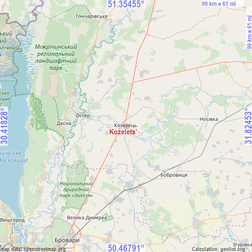
Kozelets’ GPS coordinates[2]
50° 54' 48.024" North, 31° 7' 17.04" East
| Map corner | latitude | longitude |
|---|---|---|
| Upper-left | 51.35455°, | 30.41828° |
| Center: | 50.91334°, | 31.1214° |
| Lower-right: | 50.46791°, | 31.82453° |
| Map W x H: | 98.6×98.6 km | = 61.3×61.3mi |
| max Lat: | 52.18903° ⇑4.9% North |
| Kozelets’: | 50.91334° |
| min Lat: | ⇓95.1% South 44.39214° |
| min Long | Kozelets’ | max Long |
| 22.20555° | 31.1214° | 40.13222° |
| W 39.5%⇐ | ⇒60.5% E |
Elevation
Elevation of Kozelets’ is 112 m = 367 ft, and this is 43.8 m = 144 ft below average elevation for this country.
| Max E: |
886 m = 2907 ft | 58.1% |
| Avg. | 155.8 m = 511 ft | |
| Kozelets’ | 112 m = 367 ft | |
Min E: |
-3 m = -10 ft | 41.9% |
See also: Ukraine elevation on elevation.city.
Geographical zone
Kozelets’ is located in North temperate zone (between Tropic of Cancer and the Arctic Circle). Distance of this North polar circle is 1740.1 km =1081.2 mi to North.| Distance of | km | miles | from Kozelets’ |
|---|---|---|---|
| North Pole | 4346 | 2700.5 | to North |
| Arctic Circle | 1740.1 | 1081.2 | to North |
| Tropic Cancer | 3055.1 | 1898.4 | to South |
| Equator | 5661 | 3517.6 | to South |


Nearby cities:
15 places around Kozelets’: (largest is in red/bold)
• Bobrovytsya
26.7 km =16.6 mi,  133°
133°
• Brovary
49.2 km =30.6 mi,  206°
206°
• Desna
25.3 km =15.7 mi,  273°
273°
• Khotyanivka
52.3 km =32.5 mi,  227°
227°
• Knyazhichi
55.5 km =34.5 mi, 205°
• Kobyzhcha
28.5 km =17.7 mi,  109°
109°
• Nizhyn
55.6 km =34.5 mi,  74°
74°
• Nosivka
32.4 km =20.1 mi,  86°
86°
• Olyshivka
37.4 km =23.2 mi,  23°
23°
• Oster
17.3 km =10.7 mi,  283°
283°
• Pohreby
52.1 km =32.4 mi,  220°
220°
• Pukhivka
44.1 km =27.4 mi, 220°
• Semypolky
24.6 km =15.3 mi, 212°
• Trebukhiv
50.1 km =31.1 mi,  197°
197°
• Velyka Dymerka
38.8 km =24.1 mi, 203°
Sources, notices
• [Note1] Compared only with cities in Ukraine existing in our database
• [Src1] Map data: © OpenStreetMap contributors (CC-BY-SA)
• [Src2] Other city data from geonames.org with taken over terms of usage.
• [Src3] Geographical zone / Annual Mean Temperature by Robert A. Rohde @ Wikipedia
