Desna geodata
Desna (Chernihiv) is a populated place; located in Ukraine in Europe/Kiev (GMT+3) time zone. With population of 6,906 people, there are 515 cities with bigger population in this country. Compared to other cities in Ukraine, 95.3% of cities are located further ↓South; 63.1% of cities are located further →East and 56.9% of cities have higher elevation than Desna. Note1


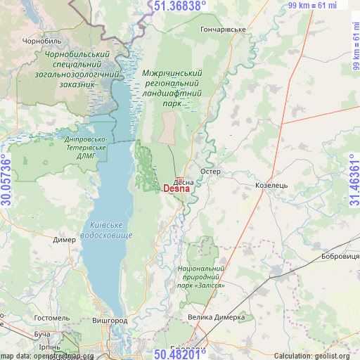
Desna GPS coordinates[2]
50° 55' 38.316" North, 30° 45' 37.728" East
| Map corner | latitude | longitude |
|---|---|---|
| Upper-left | 51.36838°, | 30.05736° |
| Center: | 50.92731°, | 30.76048° |
| Lower-right: | 50.48201°, | 31.46361° |
| Map W x H: | 98.6×98.6 km | = 61.3×61.3mi |
| max Lat: | 52.18903° ⇑4.7% North |
| Desna: | 50.92731° |
| min Lat: | ⇓95.3% South 44.39214° |
| min Long | Desna | max Long |
| 22.20555° | 30.76048° | 40.13222° |
| W 36.9%⇐ | ⇒63.1% E |
Elevation
Elevation of Desna is 115 m = 377 ft, and this is 40.8 m = 134 ft below average elevation for this country.
| Max E: |
886 m = 2907 ft | 56.9% |
| Avg. | 155.8 m = 511 ft | |
| Desna | 115 m = 377 ft | |
Min E: |
-3 m = -10 ft | 43.1% |
See also: Ukraine elevation on elevation.city.
Geographical zone
Desna is located in North temperate zone (between Tropic of Cancer and the Arctic Circle). Distance of this North polar circle is 1738.6 km =1080.3 mi to North.| Distance of | km | miles | from Desna |
|---|---|---|---|
| North Pole | 4344.5 | 2699.5 | to North |
| Arctic Circle | 1738.6 | 1080.3 | to North |
| Tropic Cancer | 3056.7 | 1899.3 | to South |
| Equator | 5662.6 | 3518.6 | to South |


Nearby cities:
15 places around Desna: (largest is in red/bold)
• Bobrovytsya
48.8 km =30.3 mi,  114°
114°
• Brovary
45.6 km =28.3 mi,  175°
175°
• Dymer
35.8 km =22.2 mi,  244°
244°
• Katyuzhanka
45.7 km =28.4 mi,  252°
252°
• Khotyanivka
39 km =24.2 mi,  199°
199°
• Kozelets’
25.3 km =15.7 mi,  93°
93°
• Liutizh
37.4 km =23.2 mi,  223°
223°
• Novi Petrivtsi
40.1 km =24.9 mi,  213°
213°
• Oster
8.9 km =5.5 mi,  73°
73°
• Pohreby
42.2 km =26.2 mi,  191°
191°
• Pukhivka
35.4 km =22 mi, 184°
• Semypolky
25.5 km =15.8 mi,  151°
151°
• Trebukhiv
50.3 km =31.3 mi,  168°
168°
• Velyka Dymerka
38.5 km =23.9 mi,  164°
164°
• Vyshhorod
42.6 km =26.5 mi, 206°
Sources, notices
• [Note1] Compared only with cities in Ukraine existing in our database
• [Src1] Map data: © OpenStreetMap contributors (CC-BY-SA)
• [Src2] Other city data from geonames.org with taken over terms of usage.
• [Src3] Geographical zone / Annual Mean Temperature by Robert A. Rohde @ Wikipedia
