Nosivka geodata
Nosivka (Chernihiv) is a seat of a second-order administrative division; located in Ukraine in Europe/Kiev (GMT+3) time zone. With population of 15,164 people, there are 254 cities with bigger population in this country. Compared to other cities in Ukraine, 95.3% of cities are located further ↓South; 58.7% of cities are located further →East and 54.5% of cities have higher elevation than Nosivka. Note1


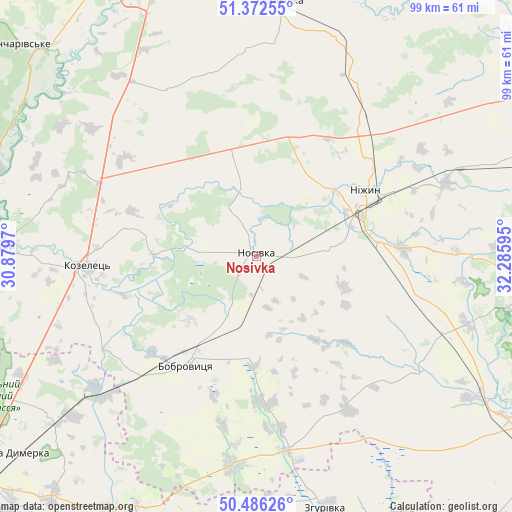
Nosivka GPS coordinates[2]
50° 55' 53.472" North, 31° 34' 58.152" East
| Map corner | latitude | longitude |
|---|---|---|
| Upper-left | 51.37255°, | 30.8797° |
| Center: | 50.93152°, | 31.58282° |
| Lower-right: | 50.48626°, | 32.28595° |
| Map W x H: | 98.5×98.5 km | = 61.2×61.2mi |
| max Lat: | 52.18903° ⇑4.7% North |
| Nosivka: | 50.93152° |
| min Lat: | ⇓95.3% South 44.39214° |
| min Long | Nosivka | max Long |
| 22.20555° | 31.58282° | 40.13222° |
| W 41.3%⇐ | ⇒58.7% E |
Elevation
Elevation of Nosivka is 121 m = 397 ft, and this is 34.8 m = 114 ft below average elevation for this country.
| Max E: |
886 m = 2907 ft | 54.5% |
| Avg. | 155.8 m = 511 ft | |
| Nosivka | 121 m = 397 ft | |
Min E: |
-3 m = -10 ft | 45.5% |
See also: Ukraine elevation on elevation.city.
Geographical zone
Nosivka is located in North temperate zone (between Tropic of Cancer and the Arctic Circle). Distance of this North polar circle is 1738.1 km =1080 mi to North.| Distance of | km | miles | from Nosivka |
|---|---|---|---|
| North Pole | 4344 | 2699.2 | to North |
| Arctic Circle | 1738.1 | 1080 | to North |
| Tropic Cancer | 3057.1 | 1899.6 | to South |
| Equator | 5663.1 | 3518.9 | to South |


Nearby cities:
15 places around Nosivka: (largest is in red/bold)
• Bobrovytsya
24.4 km =15.2 mi,  212°
212°
• Desna
57.6 km =35.8 mi,  269°
269°
• Druzhba
56.3 km =35 mi,  104°
104°
• Ichnya
57.4 km =35.7 mi, 97°
• Kobyzhcha
12.7 km =7.9 mi, 205°
• Kozelets’
32.4 km =20.1 mi, 266°
• Kruty
39.3 km =24.4 mi,  68°
68°
• Kulykivka
49.3 km =30.6 mi,  5°
5°
• Kunashëvka
32.5 km =20.2 mi, 67°
• Nizhyn
24.9 km =15.5 mi,  58°
58°
• Olyshivka
36.8 km =22.9 mi,  331°
331°
• Oster
49.1 km =30.5 mi, 272°
• Semypolky
50.9 km =31.6 mi,  243°
243°
• Talalayivka
23.9 km =14.9 mi,  82°
82°
• Zgurovka
49.8 km =30.9 mi,  163°
163°
Sources, notices
• [Note1] Compared only with cities in Ukraine existing in our database
• [Src1] Map data: © OpenStreetMap contributors (CC-BY-SA)
• [Src2] Other city data from geonames.org with taken over terms of usage.
• [Src3] Geographical zone / Annual Mean Temperature by Robert A. Rohde @ Wikipedia
