Korosten’ geodata
Korosten’ (Zhytomyr) is a seat of a second-order administrative division; located in Ukraine in Europe/Kiev (GMT+3) time zone. With population of 65,000 people, there are 72 cities with bigger population in this country. Compared to other cities in Ukraine, 95.6% of cities are located further ↓South; 74.2% of cities are located further →East and 62.7% of cities have lower elevation than Korosten’. Note1


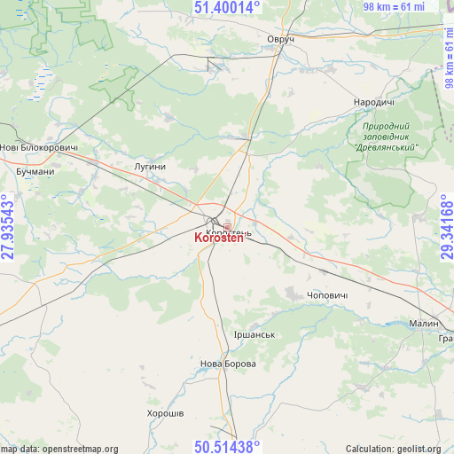
Korosten’ GPS coordinates[2]
50° 57' 33.732" North, 28° 38' 18.78" East
| Map corner | latitude | longitude |
|---|---|---|
| Upper-left | 51.40014°, | 27.93543° |
| Center: | 50.95937°, | 28.63855° |
| Lower-right: | 50.51438°, | 29.34168° |
| Map W x H: | 98.5×98.5 km | = 61.2×61.2mi |
| max Lat: | 52.18903° ⇑4.4% North |
| Korosten’: | 50.95937° |
| min Lat: | ⇓95.6% South 44.39214° |
| min Long | Korosten’ | max Long |
| 22.20555° | 28.63855° | 40.13222° |
| W 25.8%⇐ | ⇒74.2% E |
Elevation
Elevation of Korosten’ is 178 m = 584 ft, and this is 22.2 m = 73 ft above average elevation for this country.
| Max E: |
886 m = 2907 ft | 37.3% |
| Korosten’ | 178 m 584 ft | |
| Avg. | 155.8 m = 511 ft | |
Min E: |
-3 m = -10 ft | 62.7% |
See also: Korosten’ elevation on elevation.city.
Geographical zone
Korosten’ is located in North temperate zone (between Tropic of Cancer and the Arctic Circle). Distance of this North polar circle is 1735 km =1078.1 mi to North.| Distance of | km | miles | from Korosten’ |
|---|---|---|---|
| North Pole | 4340.9 | 2697.3 | to North |
| Arctic Circle | 1735 | 1078.1 | to North |
| Tropic Cancer | 3060.2 | 1901.5 | to South |
| Equator | 5666.2 | 3520.8 | to South |


Nearby cities:
15 places around Korosten’: (largest is in red/bold)
• Buchmany
43.5 km =27 mi,  286°
286°
• Cherniakhiv
56 km =34.8 mi,  177°
177°
• Chopovychi
26.2 km =16.3 mi,  122°
122°
• Druzhba
52.9 km =32.9 mi,  298°
298°
• Holovyne
55.9 km =34.7 mi,  166°
166°
• Khoroshiv
42.5 km =26.4 mi,  198°
198°
• Luhyny
21.5 km =13.4 mi,  309°
309°
• Malyn
46.9 km =29.1 mi, 116°
• Narodychi
41.2 km =25.6 mi,  48°
48°
• Nova Borova
29.6 km =18.4 mi, 180°
• Novi Bilokorovychi
44.4 km =27.6 mi, 293°
• Ovruch
42.2 km =26.2 mi,  15°
15°
• Pershotravneve
50.8 km =31.6 mi, 18°
• Pulyny
60.5 km =37.6 mi,  205°
205°
• Yemil’chyne
59.1 km =36.7 mi,  260°
260°
Sources, notices
• [Note1] Compared only with cities in Ukraine existing in our database
• [Src1] Map data: © OpenStreetMap contributors (CC-BY-SA)
• [Src2] Other city data from geonames.org with taken over terms of usage.
• [Src3] Geographical zone / Annual Mean Temperature by Robert A. Rohde @ Wikipedia
