Novi Yarylovychi geodata
Novi Yarylovychi (Chernihiv) is a populated place; located in Ukraine in Europe/Kiev (GMT+3) time zone. With population of 667 people, there are 1545 cities with bigger population in this country. Compared to other cities in Ukraine, 99.7% of cities are located further ↓South; 61.1% of cities are located further →East and 54% of cities have higher elevation than Novi Yarylovychi. Note1


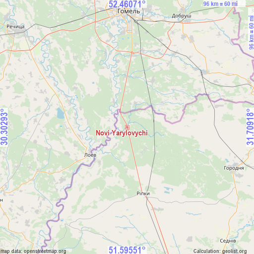
Novi Yarylovychi GPS coordinates[2]
52° 1' 48.72" North, 31° 0' 21.78" East
| Map corner | latitude | longitude |
|---|---|---|
| Upper-left | 52.46071°, | 30.30293° |
| Center: | 52.0302°, | 31.00605° |
| Lower-right: | 51.59551°, | 31.70918° |
| Map W x H: | 96.2×96.2 km | = 59.8×59.8mi |
| max Lat: | 52.18903° ⇑0.3% North |
| Novi Yarylovychi: | 52.0302° |
| min Lat: | ⇓99.7% South 44.39214° |
| min Long | Novi Yarylovych | max Long |
| 22.20555° | 31.00605° | 40.13222° |
| W 38.9%⇐ | ⇒61.1% E |
Elevation
Elevation of Novi Yarylovychi is 122 m = 400 ft, and this is 33.8 m = 111 ft below average elevation for this country.
| Max E: |
886 m = 2907 ft | 54% |
| Avg. | 155.8 m = 511 ft | |
| Novi Yarylovychi | 122 m = 400 ft | |
Min E: |
-3 m = -10 ft | 46% |
See also: Ukraine elevation on elevation.city.
Geographical zone
Novi Yarylovychi is located in North temperate zone (between Tropic of Cancer and the Arctic Circle). Distance of this North polar circle is 1616 km =1004.1 mi to North.| Distance of | km | miles | from Novi Yarylovychi |
|---|---|---|---|
| North Pole | 4221.8 | 2623.3 | to North |
| Arctic Circle | 1616 | 1004.1 | to North |
| Tropic Cancer | 3179.3 | 1975.5 | to South |
| Equator | 5785.2 | 3594.8 | to South |


Nearby cities:
15 places around Novi Yarylovychi: (largest is in red/bold)
• Berezna
73.9 km =45.9 mi,  133°
133°
• Chernihiv
61.4 km =38.2 mi,  161°
161°
• Dobryanka
12.8 km =8 mi,  73°
73°
• Horodnya
43.4 km =27 mi,  110°
110°
• Koryukivka
90 km =55.9 mi, 108°
• Kryva Hora
90.7 km =56.4 mi,  217°
217°
• Kulykivka
85.3 km =53 mi,  148°
148°
• Lyubech
43.6 km =27.1 mi,  213°
213°
• Mena
100.6 km =62.5 mi,  124°
124°
• Olyshivka
92.6 km =57.5 mi,  165°
165°
• Ripky
26 km =16.2 mi, 168°
• Sedniv
57.5 km =35.7 mi,  138°
138°
• Semenivka
108.9 km =67.7 mi,  81°
81°
• Shchors
68.5 km =42.6 mi, 110°
• Slavutych
59.8 km =37.2 mi,  199°
199°
Sources, notices
• [Note1] Compared only with cities in Ukraine existing in our database
• [Src1] Map data: © OpenStreetMap contributors (CC-BY-SA)
• [Src2] Other city data from geonames.org with taken over terms of usage.
• [Src3] Geographical zone / Annual Mean Temperature by Robert A. Rohde @ Wikipedia
