Kulykivka geodata
Kulykivka (Chernihiv) is a seat of a second-order administrative division; located in Ukraine in Europe/Kiev (GMT+3) time zone. With population of 5,739 people, there are 583 cities with bigger population in this country. Compared to other cities in Ukraine, 97.6% of cities are located further ↓South; 58.4% of cities are located further →East and 55.4% of cities have higher elevation than Kulykivka. Note1


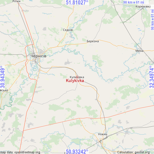
Kulykivka GPS coordinates[2]
51° 22' 24.42" North, 31° 38' 47.796" East
| Map corner | latitude | longitude |
|---|---|---|
| Upper-left | 51.81027°, | 30.94349° |
| Center: | 51.37345°, | 31.64661° |
| Lower-right: | 50.93242°, | 32.34974° |
| Map W x H: | 97.6×97.6 km | = 60.6×60.6mi |
| max Lat: | 52.18903° ⇑2.4% North |
| Kulykivka: | 51.37345° |
| min Lat: | ⇓97.6% South 44.39214° |
| min Long | Kulykivka | max Long |
| 22.20555° | 31.64661° | 40.13222° |
| W 41.6%⇐ | ⇒58.4% E |
Elevation
Elevation of Kulykivka is 119 m = 390 ft, and this is 36.8 m = 121 ft below average elevation for this country.
| Max E: |
886 m = 2907 ft | 55.4% |
| Avg. | 155.8 m = 511 ft | |
| Kulykivka | 119 m = 390 ft | |
Min E: |
-3 m = -10 ft | 44.6% |
See also: Ukraine elevation on elevation.city.
Geographical zone
Kulykivka is located in North temperate zone (between Tropic of Cancer and the Arctic Circle). Distance of this North polar circle is 1689 km =1049.5 mi to North.| Distance of | km | miles | from Kulykivka |
|---|---|---|---|
| North Pole | 4294.9 | 2668.7 | to North |
| Arctic Circle | 1689 | 1049.5 | to North |
| Tropic Cancer | 3106.3 | 1930.2 | to South |
| Equator | 5712.2 | 3549.4 | to South |


Nearby cities:
15 places around Kulykivka: (largest is in red/bold)
• Berezna
24 km =14.9 mi,  23°
23°
• Borzna
55.8 km =34.7 mi,  103°
103°
• Chernihiv
29.1 km =18.1 mi,  300°
300°
• Horodnya
57.6 km =35.8 mi,  356°
356°
• Koryukivka
60.5 km =37.6 mi,  43°
43°
• Kruty
47.3 km =29.4 mi,  137°
137°
• Kunashëvka
44.9 km =27.9 mi,  145°
145°
• Mena
42.7 km =26.5 mi,  67°
67°
• Nizhyn
39.9 km =24.8 mi,  155°
155°
• Nosivka
49.3 km =30.6 mi,  185°
185°
• Olyshivka
27.5 km =17.1 mi,  232°
232°
• Sedniv
30.7 km =19.1 mi,  349°
349°
• Shchors
53.6 km =33.3 mi, 22°
• Sosnytsya
61.4 km =38.2 mi, 74°
• Talalayivka
50 km =31.1 mi, 157°
Sources, notices
• [Note1] Compared only with cities in Ukraine existing in our database
• [Src1] Map data: © OpenStreetMap contributors (CC-BY-SA)
• [Src2] Other city data from geonames.org with taken over terms of usage.
• [Src3] Geographical zone / Annual Mean Temperature by Robert A. Rohde @ Wikipedia
