Sedniv geodata
Sedniv (Chernihiv) is a populated place; located in Ukraine in Europe/Kiev (GMT+3) time zone. With population of 1,222 people, there are 1288 cities with bigger population in this country. Compared to other cities in Ukraine, 98.8% of cities are located further ↓South; 58.8% of cities are located further →East and 50.5% of cities have lower elevation than Sedniv. Note1


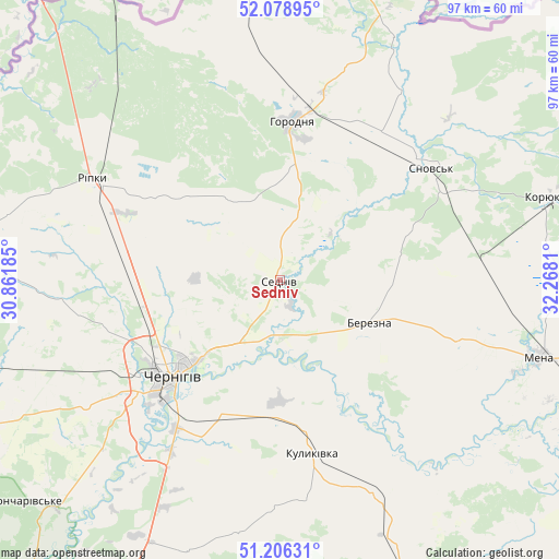
Sedniv GPS coordinates[2]
51° 38' 41.028" North, 31° 33' 53.892" East
| Map corner | latitude | longitude |
|---|---|---|
| Upper-left | 52.07895°, | 30.86185° |
| Center: | 51.64473°, | 31.56497° |
| Lower-right: | 51.20631°, | 32.2681° |
| Map W x H: | 97×97 km | = 60.3×60.3mi |
| max Lat: | 52.18903° ⇑1.2% North |
| Sedniv: | 51.64473° |
| min Lat: | ⇓98.8% South 44.39214° |
| min Long | Sedniv | max Long |
| 22.20555° | 31.56497° | 40.13222° |
| W 41.2%⇐ | ⇒58.8% E |
Elevation
Elevation of Sedniv is 138 m = 453 ft, and this is 17.8 m = 58 ft below average elevation for this country.
| Max E: |
886 m = 2907 ft | 49.5% |
| Avg. | 155.8 m = 511 ft | |
| Sedniv | 138 m = 453 ft | |
Min E: |
-3 m = -10 ft | 50.5% |
See also: Ukraine elevation on elevation.city.
Geographical zone
Sedniv is located in North temperate zone (between Tropic of Cancer and the Arctic Circle). Distance of this North polar circle is 1658.8 km =1030.7 mi to North.| Distance of | km | miles | from Sedniv |
|---|---|---|---|
| North Pole | 4264.7 | 2650 | to North |
| Arctic Circle | 1658.8 | 1030.7 | to North |
| Tropic Cancer | 3136.4 | 1948.9 | to South |
| Equator | 5742.4 | 3568.2 | to South |


Nearby cities:
15 places around Sedniv: (largest is in red/bold)
• Berezna
17.2 km =10.7 mi,  118°
118°
• Chernihiv
24.8 km =15.4 mi,  231°
231°
• Dobryanka
53.3 km =33.1 mi,  330°
330°
• Horodnya
27.5 km =17.1 mi,  4°
4°
• Koryukivka
49.1 km =30.5 mi,  73°
73°
• Kulykivka
30.7 km =19.1 mi,  169°
169°
• Lyubech
62.9 km =39.1 mi,  275°
275°
• Mena
47 km =29.2 mi,  106°
106°
• Nizhyn
70 km =43.5 mi,  161°
161°
• Novi Yarylovychi
57.5 km =35.7 mi,  318°
318°
• Olyshivka
49.6 km =30.8 mi,  198°
198°
• Ripky
37.4 km =23.2 mi,  297°
297°
• Shchors
32.5 km =20.2 mi,  53°
53°
• Slavutych
60.1 km =37.3 mi,  256°
256°
• Sosnytsya
66 km =41 mi,  101°
101°
Sources, notices
• [Note1] Compared only with cities in Ukraine existing in our database
• [Src1] Map data: © OpenStreetMap contributors (CC-BY-SA)
• [Src2] Other city data from geonames.org with taken over terms of usage.
• [Src3] Geographical zone / Annual Mean Temperature by Robert A. Rohde @ Wikipedia
