Novoaydar geodata
Novoaydar (Luhansk) is a seat of a second-order administrative division; located in Ukraine in Europe/Zaporozhye (GMT+3) time zone. In our database, there are 1661 cities with bigger population. Compared to other cities in Ukraine, 65.5% of cities are located further ↓South; 98.4% of cities are located further ←West and 77.2% of cities have higher elevation than Novoaydar. Note1


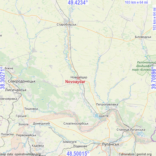
Novoaydar GPS coordinates[2]
48° 57' 50.076" North, 39° 0' 20.988" East
| Map corner | latitude | longitude |
|---|---|---|
| Upper-left | 49.4234°, | 38.30271° |
| Center: | 48.96391°, | 39.00583° |
| Lower-right: | 48.50015°, | 39.70896° |
| Map W x H: | 102.7×102.7 km | = 63.8×63.8mi |
| max Lat: | 52.18903° ⇑34.5% North |
| Novoaydar: | 48.96391° |
| min Lat: | ⇓65.5% South 44.39214° |
| min Long | Novoaydar | max Long |
| 22.20555° | 39.00583° | 40.13222° |
| W 98.4%⇐ | ⇒1.6% E |
Elevation
Elevation of Novoaydar is 53 m = 174 ft, and this is 102.8 m = 337 ft below average elevation for this country.
| Max E: |
886 m = 2907 ft | 77.2% |
| Avg. | 155.8 m = 511 ft | |
| Novoaydar | 53 m = 174 ft | |
Min E: |
-3 m = -10 ft | 22.8% |
See also: Ukraine elevation on elevation.city.
Geographical zone
Novoaydar is located in North temperate zone (between Tropic of Cancer and the Arctic Circle). Distance of this North polar circle is 1956.9 km =1216 mi to North.| Distance of | km | miles | from Novoaydar |
|---|---|---|---|
| North Pole | 4562.8 | 2835.2 | to North |
| Arctic Circle | 1956.9 | 1216 | to North |
| Tropic Cancer | 2838.4 | 1763.7 | to South |
| Equator | 5444.3 | 3382.9 | to South |


Nearby cities:
15 places around Novoaydar: (largest is in red/bold)
• Hirs’ke
45.2 km =28.1 mi,  235°
235°
• Kirovs’k
45 km =28 mi,  216°
216°
• Luhansk
49.7 km =30.9 mi,  152°
152°
• Lysychans’k
41.7 km =25.9 mi,  260°
260°
• Met’olkine
33.2 km =20.6 mi, 263°
• Rubizhne
46 km =28.6 mi,  276°
276°
• Shchastya
29.9 km =18.6 mi, 146°
• Slov`yanoserbsk
29.6 km =18.4 mi,  183°
183°
• Stanytsya Luhans’ka
48.9 km =30.4 mi,  134°
134°
• Starobil’s’k
35.6 km =22.1 mi,  348°
348°
• Syevyerodonets’k
37.6 km =23.4 mi,  267°
267°
• Toshkivka
37.4 km =23.2 mi, 236°
• Tr’okhizbenka
23.2 km =14.4 mi,  187°
187°
• Voronove
32.5 km =20.2 mi, 256°
• Zymohiria
42.4 km =26.3 mi, 186°
Sources, notices
• [Note1] Compared only with cities in Ukraine existing in our database
• [Src1] Map data: © OpenStreetMap contributors (CC-BY-SA)
• [Src2] Other city data from geonames.org with taken over terms of usage.
• [Src3] Geographical zone / Annual Mean Temperature by Robert A. Rohde @ Wikipedia
