Novhorodka geodata
Novhorodka (Kirovohrad) is a seat of a second-order administrative division; located in Ukraine in Europe/Kiev (GMT+3) time zone. With population of 6,405 people, there are 546 cities with bigger population in this country. Compared to other cities in Ukraine, 51.6% of cities are located further ↓South; 54.5% of cities are located further →East and 57.4% of cities have higher elevation than Novhorodka. Note1


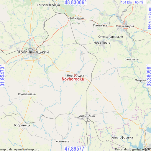
Novhorodka GPS coordinates[2]
48° 21' 54.216" North, 32° 39' 28.26" East
| Map corner | latitude | longitude |
|---|---|---|
| Upper-left | 48.83006°, | 31.95473° |
| Center: | 48.36506°, | 32.65785° |
| Lower-right: | 47.89577°, | 33.36098° |
| Map W x H: | 103.9×103.9 km | = 64.6×64.6mi |
| max Lat: | 52.18903° ⇑48.4% North |
| Novhorodka: | 48.36506° |
| min Lat: | ⇓51.6% South 44.39214° |
| min Long | Novhorodka | max Long |
| 22.20555° | 32.65785° | 40.13222° |
| W 45.5%⇐ | ⇒54.5% E |
Elevation
Elevation of Novhorodka is 114 m = 374 ft, and this is 41.8 m = 137 ft below average elevation for this country.
| Max E: |
886 m = 2907 ft | 57.4% |
| Avg. | 155.8 m = 511 ft | |
| Novhorodka | 114 m = 374 ft | |
Min E: |
-3 m = -10 ft | 42.6% |
See also: Ukraine elevation on elevation.city.
Geographical zone
Novhorodka is located in North temperate zone (between Tropic of Cancer and the Arctic Circle). Distance of this North polar circle is 2023.5 km =1257.3 mi to North.| Distance of | km | miles | from Novhorodka |
|---|---|---|---|
| North Pole | 4629.4 | 2876.6 | to North |
| Arctic Circle | 2023.5 | 1257.3 | to North |
| Tropic Cancer | 2771.8 | 1722.3 | to South |
| Equator | 5377.7 | 3341.5 | to South |


Nearby cities:
15 places around Novhorodka: (largest is in red/bold)
• Adzhamka
21.7 km =13.5 mi,  335°
335°
• Dmytrivka
48.2 km =30 mi,  5°
5°
• Dolyns'ka
29.4 km =18.3 mi,  164°
164°
• Kompaniyivka
35.6 km =22.1 mi,  249°
249°
• Kropyvnytskyi
33.7 km =20.9 mi,  299°
299°
• Molodizhne
20.9 km =13 mi,  179°
179°
• Nova Praha
28.9 km =18 mi,  38°
38°
• Novyy Starodub
41.6 km =25.8 mi,  66°
66°
• Oleksandriya
47.8 km =29.7 mi, 44°
• Oleksandriys’ke
36.1 km =22.4 mi, 41°
• Pantayivka
38.2 km =23.7 mi,  25°
25°
• Petrove
44.4 km =27.6 mi,  95°
95°
• Subottsi
33.8 km =21 mi, 342°
• Ustynivka
46.5 km =28.9 mi,  191°
191°
• Znomenka
38.7 km =24 mi,  0°
0°
Sources, notices
• [Note1] Compared only with cities in Ukraine existing in our database
• [Src1] Map data: © OpenStreetMap contributors (CC-BY-SA)
• [Src2] Other city data from geonames.org with taken over terms of usage.
• [Src3] Geographical zone / Annual Mean Temperature by Robert A. Rohde @ Wikipedia
