Kropyvnytskyi geodata
Kropyvnytskyi (Kirovohrad) is a seat of a first-order administrative division; located in Ukraine in Europe/Kiev (GMT+3) time zone. With population of 249,454 people, there are 24 cities with bigger population in this country. Compared to other cities in Ukraine, 55.5% of cities are located further ↓South; 56.4% of cities are located further →East and 57.4% of cities have higher elevation than Kropyvnytskyi. Note1


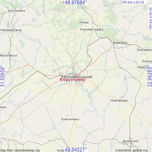
Kropyvnytskyi GPS coordinates[2]
48° 30' 47.52" North, 32° 15' 34.92" East
| Map corner | latitude | longitude |
|---|---|---|
| Upper-left | 48.97684°, | 31.55658° |
| Center: | 48.5132°, | 32.2597° |
| Lower-right: | 48.04527°, | 32.96283° |
| Map W x H: | 103.6×103.6 km | = 64.4×64.4mi |
| max Lat: | 52.18903° ⇑44.5% North |
| Kropyvnytskyi: | 48.5132° |
| min Lat: | ⇓55.5% South 44.39214° |
| min Long | Kropyvnytskyi | max Long |
| 22.20555° | 32.2597° | 40.13222° |
| W 43.6%⇐ | ⇒56.4% E |
Elevation
Elevation of Kropyvnytskyi is 114 m = 374 ft, and this is 41.8 m = 137 ft below average elevation for this country.
| Max E: |
886 m = 2907 ft | 57.4% |
| Avg. | 155.8 m = 511 ft | |
| Kropyvnytskyi | 114 m = 374 ft | |
Min E: |
-3 m = -10 ft | 42.6% |
See also: Kropyvnytskyi elevation on elevation.city.
Geographical zone
Kropyvnytskyi is located in North temperate zone (between Tropic of Cancer and the Arctic Circle). Distance of this North polar circle is 2007 km =1247.1 mi to North.| Distance of | km | miles | from Kropyvnytskyi |
|---|---|---|---|
| North Pole | 4612.9 | 2866.3 | to North |
| Arctic Circle | 2007 | 1247.1 | to North |
| Tropic Cancer | 2788.2 | 1732.5 | to South |
| Equator | 5394.2 | 3351.8 | to South |


Nearby cities:
15 places around Kropyvnytskyi: (largest is in red/bold)
• Adzhamka
20.6 km =12.8 mi,  80°
80°
• Bobrynets
51 km =31.7 mi,  187°
187°
• Dmytrivka
46 km =28.6 mi,  46°
46°
• Kompaniyivka
29.4 km =18.3 mi, 187°
• Mala Vyska
48.1 km =29.9 mi,  287°
287°
• Molodizhne
47.7 km =29.6 mi,  141°
141°
• Nova Praha
47.7 km =29.6 mi, 82°
• Novhorodka
33.7 km =20.9 mi,  119°
119°
• Oleksandrivka
50.1 km =31.1 mi,  357°
357°
• Pantayivka
49.3 km =30.6 mi,  68°
68°
• Rivne
47.6 km =29.6 mi,  231°
231°
• Subottsi
24.9 km =15.5 mi, 50°
• Yelyzavethradka
34 km =21.1 mi,  18°
18°
• Zlynka
53.2 km =33.1 mi,  266°
266°
• Znomenka
37.1 km =23.1 mi, 53°
In other languages:
- In Spanish: Kirovogrado
- In German: Kropywnyzkyj
- In Russian: Кропивницкий
- In Chinese: 基洛沃格勒
Sources, notices
• [Note1] Compared only with cities in Ukraine existing in our database
• [Src1] Map data: © OpenStreetMap contributors (CC-BY-SA)
• [Src2] Other city data from geonames.org with taken over terms of usage.
• [Src3] Geographical zone / Annual Mean Temperature by Robert A. Rohde @ Wikipedia
