Kaniv geodata
Kaniv (Cherkasy) is a seat of a second-order administrative division; located in Ukraine in Europe/Kiev (GMT+3) time zone. With population of 25,666 people, there are 161 cities with bigger population in this country. Compared to other cities in Ukraine, 78.7% of cities are located further ↓South; 59.3% of cities are located further →East and 52.7% of cities have higher elevation than Kaniv. Note1


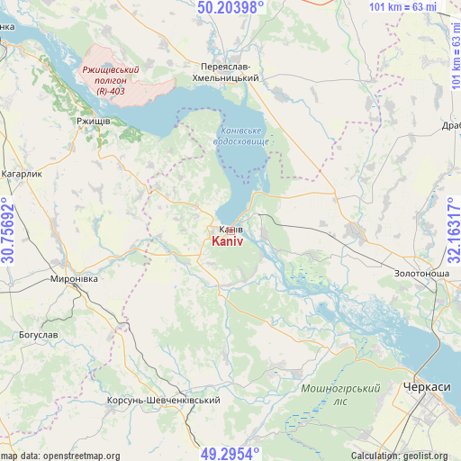
Kaniv GPS coordinates[2]
49° 45' 6.552" North, 31° 27' 36.144" East
| Map corner | latitude | longitude |
|---|---|---|
| Upper-left | 50.20398°, | 30.75692° |
| Center: | 49.75182°, | 31.46004° |
| Lower-right: | 49.2954°, | 32.16317° |
| Map W x H: | 101×101 km | = 62.8×62.8mi |
| max Lat: | 52.18903° ⇑21.3% North |
| Kaniv: | 49.75182° |
| min Lat: | ⇓78.7% South 44.39214° |
| min Long | Kaniv | max Long |
| 22.20555° | 31.46004° | 40.13222° |
| W 40.7%⇐ | ⇒59.3% E |
Elevation
Elevation of Kaniv is 126 m = 413 ft, and this is 29.8 m = 98 ft below average elevation for this country.
| Max E: |
886 m = 2907 ft | 52.7% |
| Avg. | 155.8 m = 511 ft | |
| Kaniv | 126 m = 413 ft | |
Min E: |
-3 m = -10 ft | 47.3% |
See also: Ukraine elevation on elevation.city.
Geographical zone
Kaniv is located in North temperate zone (between Tropic of Cancer and the Arctic Circle). Distance of this North polar circle is 1869.3 km =1161.5 mi to North.| Distance of | km | miles | from Kaniv |
|---|---|---|---|
| North Pole | 4475.2 | 2780.8 | to North |
| Arctic Circle | 1869.3 | 1161.5 | to North |
| Tropic Cancer | 2926 | 1818.1 | to South |
| Equator | 5531.9 | 3437.4 | to South |


Nearby cities:
15 places around Kaniv: (largest is in red/bold)
• Bohuslav
47.8 km =29.7 mi,  241°
241°
• Horodyshche
51.9 km =32.2 mi,  181°
181°
• Kaharlyk
47 km =29.2 mi,  285°
285°
• Karapyshi
49.7 km =30.9 mi,  255°
255°
• Korsun-Shevchenkivskyi
39.8 km =24.7 mi,  201°
201°
• Mliiv
46.3 km =28.8 mi,  174°
174°
• Moshny
31.9 km =19.8 mi,  141°
141°
• Myronivka
35.8 km =22.2 mi,  253°
253°
• Pereiaslav-Khmelnytskyi
35.1 km =21.8 mi,  358°
358°
• Ruska Poliana
49.9 km =31 mi, 138°
• Rzhyshchiv
38.2 km =23.7 mi,  309°
309°
• Stayki
53.9 km =33.5 mi, 312°
• Stebliv
46.9 km =29.1 mi,  213°
213°
• Tsybli
28 km =17.4 mi,  15°
15°
• Zolotonosha
42.8 km =26.6 mi,  102°
102°
Sources, notices
• [Note1] Compared only with cities in Ukraine existing in our database
• [Src1] Map data: © OpenStreetMap contributors (CC-BY-SA)
• [Src2] Other city data from geonames.org with taken over terms of usage.
• [Src3] Geographical zone / Annual Mean Temperature by Robert A. Rohde @ Wikipedia
