Mayaky geodata
Mayaky (Odesa) is a populated place; located in Ukraine in Europe/Kiev (GMT+3) time zone. With population of 636 people, there are 1559 cities with bigger population in this country. Compared to other cities in Ukraine, 61.1% of cities are located further ↑North; 69.9% of cities are located further →East and 74% of cities have lower elevation than Mayaky. Note1


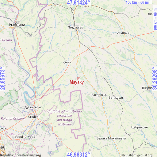
Mayaky GPS coordinates[2]
47° 26' 26.988" North, 29° 33' 35.46" East
| Map corner | latitude | longitude |
|---|---|---|
| Upper-left | 47.91424°, | 28.85673° |
| Center: | 47.44083°, | 29.55985° |
| Lower-right: | 46.96312°, | 30.26298° |
| Map W x H: | 105.8×105.8 km | = 65.7×65.7mi |
| max Lat: | 52.18903° ⇑61.1% North |
| Mayaky: | 47.44083° |
| min Lat: | ⇓38.9% South 44.39214° |
| min Long | Mayaky | max Long |
| 22.20555° | 29.55985° | 40.13222° |
| W 30.1%⇐ | ⇒69.9% E |
Elevation
Elevation of Mayaky is 220 m = 722 ft, and this is 64.2 m = 211 ft above average elevation for this country.
| Max E: |
886 m = 2907 ft | 26% |
| Mayaky | 220 m 722 ft | |
| Avg. | 155.8 m = 511 ft | |
Min E: |
-3 m = -10 ft | 74% |
See also: Ukraine elevation on elevation.city.
Geographical zone
Mayaky is located in North temperate zone (between Tropic of Cancer and the Arctic Circle). Distance of this North polar circle is 2126.2 km =1321.2 mi to North.| Distance of | km | miles | from Mayaky |
|---|---|---|---|
| North Pole | 4732.1 | 2940.4 | to North |
| Arctic Circle | 2126.2 | 1321.2 | to North |
| Tropic Cancer | 2669 | 1658.4 | to South |
| Equator | 5274.9 | 3277.7 | to South |


Nearby cities:
15 places around Mayaky: (largest is in red/bold)
• Ananyiv Pershyi
42.5 km =26.4 mi,  42°
42°
• Balta
55.2 km =34.3 mi,  4°
4°
• Kuchurhan
35.4 km =22 mi,  150°
150°
• Lyubashivka
68.5 km =42.6 mi,  49°
49°
• Okny
13.4 km =8.3 mi,  325°
325°
• Peschana
77.6 km =48.2 mi,  9°
9°
• Podil’s’k
34.8 km =21.6 mi,  356°
356°
• Rozdil’na
77.2 km =48 mi, 149°
• Shyryayeve
48.4 km =30.1 mi,  97°
97°
• Slobidka
52.1 km =32.4 mi,  342°
342°
• Stepanivka
78.8 km =49 mi,  155°
155°
• Velyka Mykhaylivka
46 km =28.6 mi, 150°
• Velykoploske
48.4 km =30.1 mi,  169°
169°
• Zakharivka
19.2 km =11.9 mi,  128°
128°
• Zatyshshya
26.4 km =16.4 mi,  116°
116°
Sources, notices
• [Note1] Compared only with cities in Ukraine existing in our database
• [Src1] Map data: © OpenStreetMap contributors (CC-BY-SA)
• [Src2] Other city data from geonames.org with taken over terms of usage.
• [Src3] Geographical zone / Annual Mean Temperature by Robert A. Rohde @ Wikipedia
