Balta geodata
Balta (Odesa) is a seat of a second-order administrative division; located in Ukraine in Europe/Kiev (GMT+3) time zone. With population of 19,220 people, there are 209 cities with bigger population in this country. Compared to other cities in Ukraine, 57.6% of cities are located further ↑North; 69.6% of cities are located further →East and 53.6% of cities have higher elevation than Balta. Note1


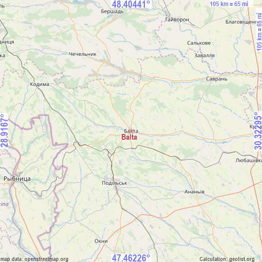
Balta GPS coordinates[2]
47° 56' 7.728" North, 29° 37' 11.352" East
| Map corner | latitude | longitude |
|---|---|---|
| Upper-left | 48.40441°, | 28.9167° |
| Center: | 47.93548°, | 29.61982° |
| Lower-right: | 47.46226°, | 30.32295° |
| Map W x H: | 104.8×104.8 km | = 65.1×65.1mi |
| max Lat: | 52.18903° ⇑57.6% North |
| Balta: | 47.93548° |
| min Lat: | ⇓42.4% South 44.39214° |
| min Long | Balta | max Long |
| 22.20555° | 29.61982° | 40.13222° |
| W 30.4%⇐ | ⇒69.6% E |
Elevation
Elevation of Balta is 123 m = 404 ft, and this is 32.8 m = 108 ft below average elevation for this country.
| Max E: |
886 m = 2907 ft | 53.6% |
| Avg. | 155.8 m = 511 ft | |
| Balta | 123 m = 404 ft | |
Min E: |
-3 m = -10 ft | 46.4% |
See also: Ukraine elevation on elevation.city.
Geographical zone
Balta is located in North temperate zone (between Tropic of Cancer and the Arctic Circle). Distance of this North polar circle is 2071.2 km =1287 mi to North.| Distance of | km | miles | from Balta |
|---|---|---|---|
| North Pole | 4677.1 | 2906.2 | to North |
| Arctic Circle | 2071.2 | 1287 | to North |
| Tropic Cancer | 2724 | 1692.6 | to South |
| Equator | 5329.9 | 3311.8 | to South |


Nearby cities:
15 places around Balta: (largest is in red/bold)
• Ananyiv Pershyi
34 km =21.1 mi,  134°
134°
• Bershad
48.7 km =30.3 mi,  351°
351°
• Chechelnyk
36.3 km =22.6 mi,  328°
328°
• Hayvoron
48.6 km =30.2 mi,  22°
22°
• Kodyma
41.1 km =25.5 mi,  296°
296°
• Kryve Ozero
54.4 km =33.8 mi,  88°
88°
• Lyubashivka
49 km =30.4 mi,  102°
102°
• Mayaky
55.2 km =34.3 mi,  184°
184°
• Okny
45.5 km =28.3 mi,  195°
195°
• Peschana
23.1 km =14.4 mi, 20°
• Podil’s’k
21.3 km =13.2 mi, 197°
• Savran
40.8 km =25.4 mi,  57°
57°
• Slobidka
21.1 km =13.1 mi,  255°
255°
• Viytivka
54.8 km =34.1 mi, 354°
• Zavallya
42.7 km =26.5 mi,  43°
43°
Sources, notices
• [Note1] Compared only with cities in Ukraine existing in our database
• [Src1] Map data: © OpenStreetMap contributors (CC-BY-SA)
• [Src2] Other city data from geonames.org with taken over terms of usage.
• [Src3] Geographical zone / Annual Mean Temperature by Robert A. Rohde @ Wikipedia
