Velyka Mykhaylivka geodata
Velyka Mykhaylivka (Odesa) is a seat of a second-order administrative division; located in Ukraine in Europe/Kiev (GMT+3) time zone. With population of 5,777 people, there are 579 cities with bigger population in this country. Compared to other cities in Ukraine, 63.4% of cities are located further ↑North; 68.5% of cities are located further →East and 78.7% of cities have higher elevation than Velyka Mykhaylivka. Note1


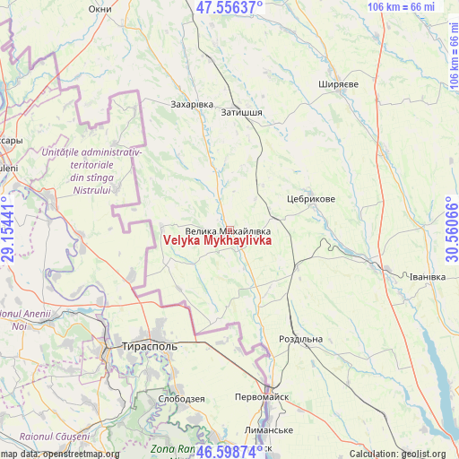
Velyka Mykhaylivka GPS coordinates[2]
47° 4' 46.956" North, 29° 51' 27.108" East
| Map corner | latitude | longitude |
|---|---|---|
| Upper-left | 47.55637°, | 29.15441° |
| Center: | 47.07971°, | 29.85753° |
| Lower-right: | 46.59874°, | 30.56066° |
| Map W x H: | 106.5×106.5 km | = 66.2×66.2mi |
| max Lat: | 52.18903° ⇑63.4% North |
| Velyka Mykhaylivka: | 47.07971° |
| min Lat: | ⇓36.6% South 44.39214° |
| min Long | Velyka Mykhayli | max Long |
| 22.20555° | 29.85753° | 40.13222° |
| W 31.5%⇐ | ⇒68.5% E |
Elevation
Elevation of Velyka Mykhaylivka is 48 m = 157 ft, and this is 107.8 m = 354 ft below average elevation for this country.
| Max E: |
886 m = 2907 ft | 78.7% |
| Avg. | 155.8 m = 511 ft | |
| Velyka Mykhaylivka | 48 m = 157 ft | |
Min E: |
-3 m = -10 ft | 21.3% |
See also: Ukraine elevation on elevation.city.
Geographical zone
Velyka Mykhaylivka is located in North temperate zone (between Tropic of Cancer and the Arctic Circle). Distance of this North polar circle is 2166.4 km =1346.1 mi to North.| Distance of | km | miles | from Velyka Mykhaylivka |
|---|---|---|---|
| North Pole | 4772.3 | 2965.4 | to North |
| Arctic Circle | 2166.4 | 1346.1 | to North |
| Tropic Cancer | 2628.9 | 1633.5 | to South |
| Equator | 5234.8 | 3252.8 | to South |


Nearby cities:
15 places around Velyka Mykhaylivka: (largest is in red/bold)
• Ananyiv Pershyi
71.6 km =44.5 mi,  5°
5°
• Bilyayivka
71.7 km =44.6 mi,  157°
157°
• Ivanivka
47.8 km =29.7 mi,  103°
103°
• Kuchurhan
10.6 km =6.6 mi,  330°
330°
• Lymanske
47.9 km =29.8 mi,  169°
169°
• Mayaky
46 km =28.6 mi, 330°
• Okny
59.4 km =36.9 mi, 329°
• Pavlivka
36.8 km =22.9 mi, 164°
• Rozdil’na
31.2 km =19.4 mi,  147°
147°
• Shyryayeve
42.1 km =26.2 mi,  37°
37°
• Stepanivka
33.2 km =20.6 mi, 162°
• Stepove
45.1 km =28 mi, 158°
• Velykoploske
15.9 km =9.9 mi,  242°
242°
• Zakharivka
29.1 km =18.1 mi,  345°
345°
• Zatyshshya
28.2 km =17.5 mi,  2°
2°
Sources, notices
• [Note1] Compared only with cities in Ukraine existing in our database
• [Src1] Map data: © OpenStreetMap contributors (CC-BY-SA)
• [Src2] Other city data from geonames.org with taken over terms of usage.
• [Src3] Geographical zone / Annual Mean Temperature by Robert A. Rohde @ Wikipedia
