Rozdil’na geodata
Rozdil’na (Odesa) is a seat of a second-order administrative division; located in Ukraine in Europe/Kiev (GMT+3) time zone. With population of 17,615 people, there are 222 cities with bigger population in this country. Compared to other cities in Ukraine, 64.7% of cities are located further ↑North; 67.4% of cities are located further →East and 53.3% of cities have lower elevation than Rozdil’na. Note1


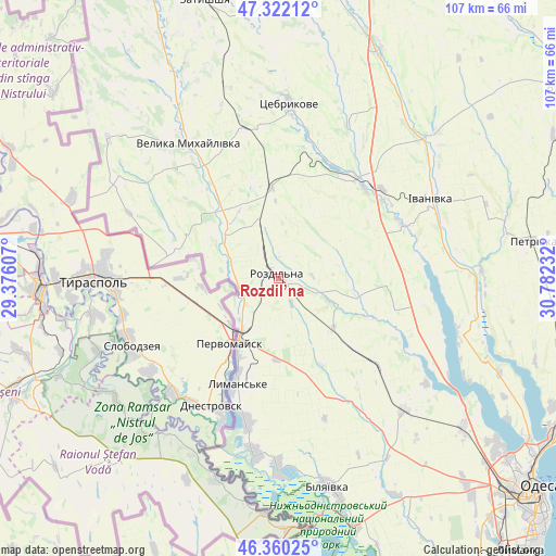
Rozdil’na GPS coordinates[2]
46° 50' 36.024" North, 30° 4' 45.084" East
| Map corner | latitude | longitude |
|---|---|---|
| Upper-left | 47.32212°, | 29.37607° |
| Center: | 46.84334°, | 30.07919° |
| Lower-right: | 46.36025°, | 30.78232° |
| Map W x H: | 106.9×106.9 km | = 66.4×66.4mi |
| max Lat: | 52.18903° ⇑64.7% North |
| Rozdil’na: | 46.84334° |
| min Lat: | ⇓35.3% South 44.39214° |
| min Long | Rozdil’na | max Long |
| 22.20555° | 30.07919° | 40.13222° |
| W 32.6%⇐ | ⇒67.4% E |
Elevation
Elevation of Rozdil’na is 146 m = 479 ft, and this is 9.8 m = 32 ft below average elevation for this country.
| Max E: |
886 m = 2907 ft | 46.7% |
| Avg. | 155.8 m = 511 ft | |
| Rozdil’na | 146 m = 479 ft | |
Min E: |
-3 m = -10 ft | 53.3% |
See also: Ukraine elevation on elevation.city.
Geographical zone
Rozdil’na is located in North temperate zone (between Tropic of Cancer and the Arctic Circle). Distance of this North polar circle is 2192.7 km =1362.5 mi to North.| Distance of | km | miles | from Rozdil’na |
|---|---|---|---|
| North Pole | 4798.6 | 2981.7 | to North |
| Arctic Circle | 2192.7 | 1362.5 | to North |
| Tropic Cancer | 2602.6 | 1617.2 | to South |
| Equator | 5208.5 | 3236.4 | to South |


Nearby cities:
15 places around Rozdil’na: (largest is in red/bold)
• Bilyayivka
41.4 km =25.7 mi,  165°
165°
• Ivanivka
33.1 km =20.6 mi,  63°
63°
• Kremidivka
55.1 km =34.2 mi,  102°
102°
• Kuchurhan
41.8 km =26 mi,  328°
328°
• Lymanske
22.5 km =14 mi,  202°
202°
• Mayaky
49.6 km =30.8 mi,  162°
162°
• Pavlivka
11.6 km =7.2 mi,  217°
217°
• Starokozache
56.7 km =35.2 mi,  187°
187°
• Stepanivka
8.9 km =5.5 mi,  232°
232°
• Stepove
15.5 km =9.6 mi,  180°
180°
• Teplodar
42 km =26.1 mi,  153°
153°
• Usatove
56.1 km =34.9 mi,  127°
127°
• Velyka Mykhaylivka
31.2 km =19.4 mi, 327°
• Velykoploske
36.2 km =22.5 mi,  301°
301°
• Zatyshshya
56.7 km =35.2 mi,  344°
344°
Sources, notices
• [Note1] Compared only with cities in Ukraine existing in our database
• [Src1] Map data: © OpenStreetMap contributors (CC-BY-SA)
• [Src2] Other city data from geonames.org with taken over terms of usage.
• [Src3] Geographical zone / Annual Mean Temperature by Robert A. Rohde @ Wikipedia
